
Spanning the River Dee and delivering barges via the Shropshire Union Canal for over 200 years, the Pontcysyllte Aqueduct is a spectacular piece of engineering that is a must-see for anyone in the area. Well deserving of its UNESCO World Heritage status, the aqueduct is an amazing sight from down on the ground or looking out over those incredible views from the top. On paper, it may seem like a bit of a big bridge, but there is so much to see and do around here you could easily spend a whole day adventuring here! From the river walks to the canal towpaths, wooded sections and Welsh towns to explore you can simply pick a direction and get to walking, or jump on a tour boat if that is more your speed.
Pontcysyllte Aqueduct sits between the settlements of Froncysyllte and Trevor along the River Dee, about 8 miles south of Wrexham. You can approach from either side of the river, although parking is mostly on the north side. If approaching from the South, take the A5 into Froncysyllte before turning down the narrow-ish B5434 (it is mostly fine but with choke points where only a single vehicle is able to pass) before descending to cross the river on the spectacular Pont Cysyllte (Cysyltau Bridge), this is a single width bridge with a view of the aqueduct to your right - after the bridge, follow the road around to the right and you will ascend into Trevor. Approaching from the north, follow the A483 until you turn onto the A539, following signs for Llangollen. The A539 will take you pretty much all the way there, just keep an eye out for the turning at Trevor or for the Canal Boat Trips as there are multiple parking options available here. You have to major options for local parking, the closest car park is right on the edge of Trevor Basin down a small road - this one is tiny so you will need to arrive early to grab a space. The second closest car park is Read's Yard Car park, although this is a short stay car park - instead, you may prefer to go to the larger car park just a short walk from Trevor Basin, this is a very reasonable distance from the aqueduct and means you do not have to travel into the town of Trevor itself. From this car park, just walk up the narrow road alongside and you will emerge at Trevor Basin.

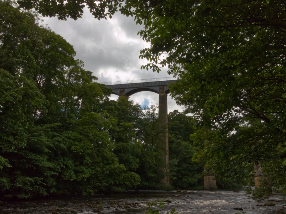
Now, as I have mentioned Trevor Basin several times already - let us begin with it, this is a picturesque little mooring ground for barges and tour boats which has plenty of amenities worth having a wander around before heading on to the main event. The basin had originally been part of the planned extension to Chester, if you walk the north end of the basin you can see the canal split into two and just end abruptly where it would have connected through. Instead, it is a quiet space with a visitors centre, cafes, public toilets and even an adjacent pub. Tour boats will typically have a sandwich board next to their moorings advertising their tours so they can easily be found and travel the canal fairly often. Walking towards the aqueduct there is another canal off to the right, this is the continuation of the Llangollen Canal (Part of the Shropshire Union Canal) that, if you fancy a grander adventure, can be walked all the way to Horseshoe falls. Otherwise. from the basin you can either walk straight out onto the aqueduct or take a branching path to get a picture-perfect look at those arches from below.
Firstly, let us walk Pontcysyllte Aqueduct. The path itself is barely wide enough for two people, with a handrail only on the side of the large drop down to the River Dee. The canal side of the path is open, like walking a typical canal towpath, but the furthest side also has no protection either which can feel a little unnerving if you don't like heights! Generally, the walk is fine, but if you don't like heights, water or any combination thereof then you may just have to psyche yourself up for this one before heading out. Once out onto the aqueduct you should take some time to enjoy the views, but be considerate of other walkers and make sure you don't block the paths entirely (for example, any time I stopped I removed my backpack and stood as close to the railing as possible to be out of the way). Alternatively, if you choose to do a boat tour then you can putter along at a leisurely pace while enjoying those same views off of the side. Of all of the things I was expecting to see from the top of the aqueduct, what I did not expect to see was what appeared to be another one! Off in the distance is Traphont Cefn Mawr Viaduct, as the name may give away this one doesn't transport water but instead gets trains over the River Dee and across the valley in an awe-inspiring manner.

It is very important to take some time to explore the surrounding areas at Pontcysyllte Aqueduct, not just because they can offer some amazing viewpoints of the aqueduct itself but because they are lovely in their own regard. Rolling Welsh hills littered with farms and wooded areas plus all the sleepy little hamlets combine to make the perfect countryside adventure. Taking the path previously mentioned down from Trevor Basin and along the River Dee will allow you to look up at the aqueduct and marvel at its staggering size, but taking some time to walk some of the other attractions in the area such as the spectacular Traphont Cefn Mawr Viaduct (not accessible on foot but still worth seeing!) is well worth the effort. In the walk above, we only chart a path to walk the aqueduct and view the river but I have included some additional landmarks that you could easily extend your day with.
The history of this amazing structure is fairly short - Pontcysyllte Aqueduct was designed by Thomas Telford and William Jessop in the late 18th-century and opened in 1805, the plan was for the canal to link through Moss Valley in Wrexham which would complete the link between Trevor Basin all the way to Chester. Partway through the construction of the aqueduct, this link was cancelled, and so Trevor Basin became the northern terminus of the canal route. In order to maintain the water levels in the canal, a feeder channel was added from Llangollen and a weir constructed: horseshoe falls. By 1846 the canal became a part of the Shropshire Union Railways and Canal Company, with the initial plan being to convert the canals to railways - this plan ended up never coming to fruition, and the canal was allowed to continue operation as long as it was profitable. It operated steadily until a water breach at Newtown in Powys in 1936 hindered its operations, and by 1939 no boats were crossing the aqueduct. It fell into disrepair after its formal closure in 1944, but its existence was saved thanks to the aqueduct itself being a feeder for the Shropshire Union Canal, and being a source of drinking water - the Mid & South East Cheshire Water Board agreed to continue maintenance on the aqueduct and secured its future, before eventually coming under the control of the Canal & River Trust.
There is nothing I love more than the combination of a bit of history in glorious scenary, and Pontcysyllte Aqueduct ticks both of those boxes perfectly. This is a great place for a 20-minute stroll or an entire days adventure, a wonderful location full of beautiful places to explore and an amazing piece of our industrial heritage at the centre. Get yourself out here to see everything this serene section of Wales has on offer, from the gently rolling hills to the patchwork of farmland mixed with dense trees, the countryside is the perfect frame for this gorgeous attraction.
