UK Rivers
Posted by Dan | Feb 28th, 2021 - 8:05pm

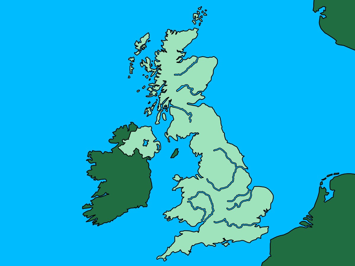
In our last quiz, we tested your general knowledge of rivers, now its time to test your geography of UK rivers! These ten questions will give you the route of some of the UK's best-known rivers, all you need to do is name the correct one. These 10 rivers have something that links them, but for now, just follow the clues and see if you know your rivers of the United Kingdom!
Starting its course in the Cambrian Mountains on the Plynlimon massif, this river snakes its way through Powys, passing via settlements such as Newtown and Welshpool before crossing the border into England. Once in England, the river gradually turns south while passing through a handful of sizeable settlements as it routes through Shropshire, Worcestershire and Gloucestershire before ending at one of the highest tidal range estuaries in the world. While exploring this river, you may encounter such landmarks as the iconic Iron bridge and a sandstone castle in Shropshire, a beautiful cathedral in Worcestershire and if you visit at the right time of year you may even see a bore.
The origins of this river can be found on the slopes of Ben Lui, but it isn't born until it springs forth from a loch sharing the same name. This river is a highland course curving through Perth and eventually passing alongside Dundee as a tidal estuary. While not appearing to be of any grand stature, if you were to rank the United Kingdom's rivers by discharge, this one would rank number 1. From Loch to the North Sea, you can encounter Crannogs, see Macbeth's tree and even play golf on a river island.
From Gloucestershire in the Cotswolds, passing through the likes of Oxford, Reading and eventually into London, this iconic UK river meanders lazily through both countryside and urban sprawl. Thanks to its prominent position in the capital, this river has likely been seen in media by just about everyone but is extra familiar to soap fans.
This river is a tricky one to discuss because it manages to change its name partway through. It seems hard to pinpoint exactly why this happens, but as a bonus for you, I will give you the first part of this rivers name. Springing at Ure head, the River Ure is a 74-mile river curving around the North/North-East edge of the Yorkshire Dales before passing near the city of Ripon. Eventually, the Ure meets with a stream and partially assumes its second name. Our new river heads straight through the city of York before angling further south to meet with another river to form the Humber. This river spends a good portion of its time in the countryside or passing via smaller settlements, but tourists in York are never far from this river, whether you are standing atop Clifford's Tower, exploring the grounds of the Yorkshire Museum or walking in Rowntree Park.
Springing from three sources in Northamptonshire, this river makes its way through Northampton, Wellingborough and Peterborough before meeting the North Sea at The Wash. The river connects with the Grand Union Canal and spends large sections of its route surrounded by lakes, including those at Barnwell Country Park, Ditchford Lakes And Meadows, Higham Ferrers Pits, Irthlingborough Lakes And Meadows, Stanwick lakes and more. Considerable sections of the river have been developed for navigation and include adjacent water-routes and locks at regular intervals. This river is a spectacular sight from above, between the patchworks of lakes and arrow-straight canals.
Previously we talked about the Humber - the tidal estuary in the North East of England, that forms at the confluence of two rivers. One of the rivers was the answer to a previous question, this is the other river. This river forms in Staffordshire and is considered to be the boundary between the Midlands and the North. This river passes through some major settlements, including Stoke, Stone, Rugeley, Burton and Nottingham (some of those have 'on' or 'upon' in their name, but we can't make it THAT easy...). You will have seen this river if you have ever set foot on Newark Castle, cross the Medieval bridge at Swarkestone or taken off from East Midlands airport.
You may be experiencing deja vu, considering this is another river born of the Cambrian Mountains and not only that but another river from the Plynlimon massif. To make matters worse, this river also ends in the same place as that previous river. Before you chalk this one up as a duplicate, this rivers shorter course sees it take a more direct route to the sea via Powys and straight into Herefordshire, via Hereford itself, before ending as the border between Gloucestershire and Monmouthshire via a Valley and Area of National Beauty (AONB) sharing its name with the river. There are plenty of beautiful places to visit along this long stretching river, including Goodrich Castle, Tintern Abbey and Chepstow Castle.
You know when a river is described as "important for Salmon and Whisky production" it is going to be in Scotland. Another Scottish river born of a loch sharing its name, the river descends through the countryside heading east before once again expanding as it arrives at a dam. The flows beyond the dam continue through the countryside, turning north and passing through Loch Insh and meets with the river Druie at Aviemore, before continuing on to join the Sea - somewhere familiar to anyone who has visited the WDC Scottish Dolphin Centre. It may not pass through many major settlements, but it is the fastest flowing river in Scotland, and its distilleries produce more Whisky than those in any other region.
This next river starts its flow from near Syresham in Northamptonshire, from which it meanders into Buckinghamshire where it comes to form the northern edge of Milton Keynes before bisecting Bedford and making its way gradually north. The river splits into man-made sections, with the old and new Bedford Rivers, bolting out in straight lines whereas the river continues in a more leisurely path through Ely before meeting back with the canals. Finally, it passes through King's Lynn before joining the sea at The Wash. This is another river that looks great from above, with the canal systems and lakes making for a striking landscape. But even on the ground, whether visiting National Trust's Houghton Mill, walking St Ives bridge or exploring the grounds at Stantonbury Manor, there is still plenty of beauty to be discovered!
Our final river is born of two streams, Daer Water and Potrail Water - you might not be aware of these but you could have passed them while walking the Southern Upland Way. The river makes its way north, following roads and passing by hamlets and villages until before carving straight through Glasgow centre before meeting the sea at a confluence with several lochs and a Firth sharing the river's name. Take some time when in the area to see the Scottish Wildlife Trust maintained falls along this river, explore RSPB Baron's Haugh or while wandering the grounds at Bothwell Castle.
Your final score was... 0 out of 10

Always stay up to date
Never miss a post! Click the button to get notified on your device whenever new content goes live.
When you click the button your browser may display a prompt to display notifications, if this doesn't display you may have already disabled notifications.
We will never spam you, and only ever push notifications when we have something for you!
