
The beauty of Ty'n y Groes cannot be underestimated - this southern section of the charming Coed y Brenin has so many great vistas and beautiful stretches of woodland that it deserves exploring thoroughly. We have been here before, finding great places to snap many a photo around the Glasdir Copper Trail. So on another recent visit, we decided to pick another trail and find out what Ty'n y Groes has to offer, and boy did it deliver! This is the Mynydd Penrhos Mountain Trail, the green trail and the one labelled as the toughest that you can do from our start point. This trail will take you out along the river before diverting up Mynydd Pen-rhos - to be clear, this walk is not a mountain ascent as you may have believed from the name, but rather a nice hill at just over 200 meters of ascent, which provides great views of neighbouring mountains. But as the board describes, the narrow tracks and continuous ascents are a great way to get a taste of what mountain ascents feel like around Wales, and I would also add my stamp onto this and say this is a great way to trial whether or not you might be up to your first mountain climb. If you can manage this ascent, enjoy the types of climbs you encounter and feel like you still have plenty of energy left in the tank, then I say your next step could well be up a Welsh mountain...
Getting into Ty'n y Groes is easy, mostly down smooth and wide A-roads from all directions, and unlike the Copper Trail, this walk does not require you to make your way down the narrow tracks within the woodlands; instead, you only need to park up in the first car park just across the bridge to begin. The entrance to Ty'n y Groes is just off the A470 and pretty easy to spot from its adjacent brown sign - just south of the town of Ganllwyd, you can easily connect through from Dolgellau to the south and Blaenau Ffestiniog to the North. Make your way across the bridge and cattle grid and then park up in the car park on your right, next to the facilities. Travelling via public transport is limited, but a bus route does connect through here and stops at Ty'n y Groes Hotel, about a quarter of a mile walk away from the entrance. Lines between Aberystwyth and Caernarfon currently stop there, and run fairly regularly for a Welsh bus.


Our walk takes us from the entrance and down along the Afon Mawddach, following a route shared with the yellow and blue paths, with some of the other paths at Ty'n y Groes - don't let this section lull you into a false sense of security, before long, you will be breaking away. For now, enjoy the smooth paths and take some time to get some great views of the Afon Mawddach. You also get to see some of the many Douglas Firs here. These towering trees were brought here at the start of the 20th century from the western Rocky Mountains, North America - the tallest of these trees is just shy of 50 meters tall, with a trunk over 1 meter wide. This portion of the walk is a lovely warm-up, and a nice loop for dog walkers or a more casual outing - make the most of it while it is here...
Before you know it, things will quickly change, you cross a track, and suddenly the path goes from smooth to something quite different! This first section undulates along a fairly narrow track - before we get into that, though, a bit of a side-note... Our journey had a unique spanner in the works, we were actually visiting Ty'n y Groes between storms (a week of three different weather warnings in fact), and so we had planned for exceptionally muddy conditions and perhaps a cold breeze at the top (luckily, it actually ended up being quit a warm day), but the first sign of the storm greeted us quickly into the walk. Unfortunately for us, the path ahead was blocked by a downed tree, perfectly placed to be a real roadblock. After having partially clambered my way up to the trunk of the tree, I deduced that with the aid of hiking sticks, we should just about be able to prop ourselves up and push ourselves over. It was tricky, but we managed it - this had the added bonus of an already quiet day in the woods being even quieter, with any other walkers likely put off by this obstacle! I only add this as I wanted to take a moment to highlight how dangerous downed trees can be - I would only recommend doing this if you can do two things: firstly, make sure the tree is not going anywhere, and ideally, try to balance yourself with feet on the ground, rather than on the trunk or limbs of the tree. The second, and more important thing, is to avoid going anywhere near the roots - if you can see the tree's root plate at the base of the trunk, and the hole where it once stood, stay well clear. This is because, in certain conditions, especially on fairly recently fallen trees, they can stand back up - being in the root hole can result in injury or death.


Beyond the unexpected difficulty we faced, the Mynydd Penrhos trail did offer a great collection of varied terrains and gradients to sink our teeth into. This is certainly not a walk I would consider particularly accessible, but instead a challenging array of stone, roots and muddy sections to dirty your boots in. Initially, the walk is a good mix of ups, downs and flats, occasional sequences of steps to help out, but mostly just dirt and loose stone paths to guide the way. The route climbs upwards, crosses mountain bike trails and occasionally gives views out to the right of some drops, but before long you will arrive at a logging road with a turnaround point which you cross to continue on the trail, for our visit it appears the area had recently been clear cut, which was a shame although it did make for better views later on...
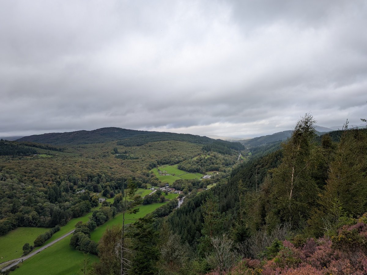
From the logging road, our final ascent in Mynydd Penrhos would begin. This last stretch is the steepest uphill section, but doesn't drag on too far, and you have the added motivator that once it is over, it will be all downhill from here! Plus, if you ever find yourself out of breath, then you just need to turn around and enjoy the ever-growing stunning views already on offer. OS maps mark two viewpoints at the top, but for our visit in the peak of summer, we were only really able to see the views from one side due to overgrowth, but they did not disappoint - the beautiful views at the top made all the climbing worthwhile, and the bench made for the perfect spot to have a little picnic while recharging.


Now the descent can begin, after crossing the peak of Mynydd Penrhos, your way down will feel very much like your ascent, only much easier naturally. Stretches of dense woodland give way to open stretches and swampy sections - all pushing you on at a good pace as gravity assists your return journey. You will make progress quickly, and before long, you will rejoin the gravel woodland roads briefly before dropping down the other side and rejoining the river at the same stretch where you left it at the start of your adventure. Before you know it, you will find yourself back at the entrance to Ty'n y Groes and concluding this great little loop!
So that just about sums up the Mynydd Penrhos Mountain trail loop at Ty'n y Groes, a great little dip into the world of mountain climbing without committing to a three-hour lap of your local peak, a great tester for someone trying to see if they are capable of mountain walks, but also a walk I genuinely recommend on its own merits. The serene woodlands and gorgeous vistas combine for a walk worthy of anyone's time, regardless of experience level, and if you find yourself in the area, then this is a worthy stop off! The great news is, if you are looking to combine this with other walks, then you are spoilt for choice here, with other walks in Ty'n y Groes such as the Glasdir Copper Trail easily tacked on, the neighbouring Coed y Brenin and its stunning waterfall walk just up the road, and one of our favourite waterfall walks at Coed Ganllwyd in between! Just check out our collection of nearby attractions above to see all the great options on offer in this stunning section of Snowdonia (Eryri).
