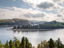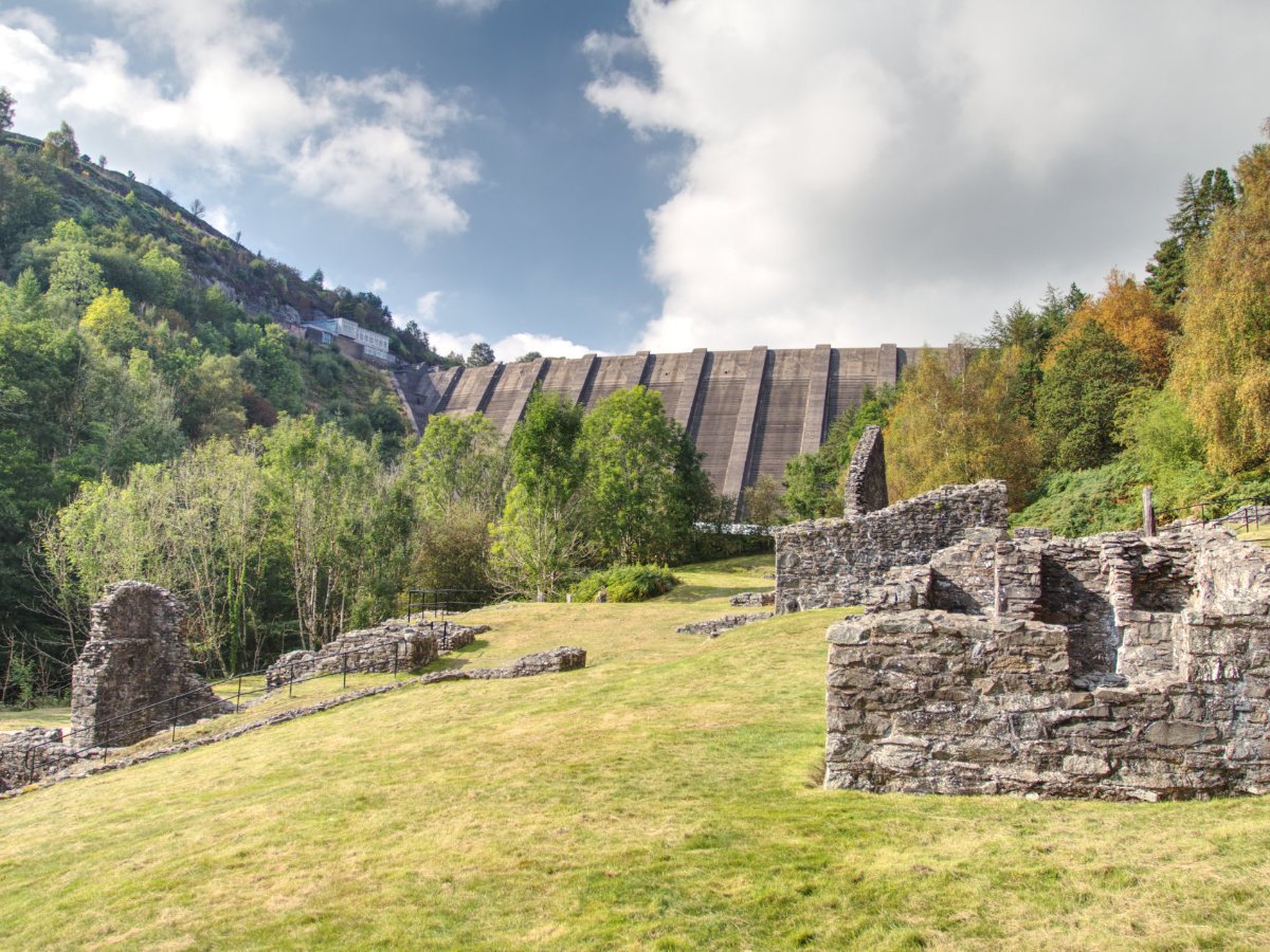

The dam at Llyn Clywedog is an impressive structure, being the tallest concrete dam in the United Kingdom, and it certainly warrants a trip if you find yourself in the area but there is a great little day out sat in its shadow that I wish to discuss today: Bryntail Lead Mine (Gwaith Mwyn Plwm Bryntail). This mine's entire operation happened prior to the lake's existence so it is hard to imagine how this valley would have looked back when the buildings were full of life rather than in ruin and the tools were in full swing. It may only be a quick little stop that you can easily slide into a grander adventure but that doesn't mean it isn't worth your time, and with a little creativity you could easily connect this into bigger walks or just drop in as you pass through mid-Wales. Whatever your plans, let us see if we can't tempt you with a drop in at Bryntail...
We discussed getting there in our article on Llyn Clywedog, but to recap: You can basically connect through from most places in Wales by following the B4518. To the south is the town of Llanidloes, where you are likely to set out from if on public transport, and to the north is Snowdonia and all of its wonders. As you follow the road you should spot brown signs for Bryntail Lead Mine (as well as Llyn Clywedog and Coedwig Hafren Forest) - you will be following the same roads as you would for the dam on the lake, but taking a turning a little earlier where the brown sign is for Gwaith Mwyn Plwm Bryntail/Bryntail lead mine. The unnamed road to the mine starts out nice and easy to follow as while it does not have a centre dividing line it is plenty wide enough, unfortunately, the same cannot be said for the approach road to the mine's parking; the road down to the parking is a single track road, but it is both short and only has one real corner to deal with so you should have no problems getting down to the handful of parking spaces (Remember to be respectful of the homeowner(s) here as a couple of houses look out over the car park). Public transport is a little limited in the area, with the only bus stops at Llanidloes, which would require roughly a 4-mile walk, so you may want to plan for a taxi or at least be prepared for a good walk from the town. For those eager for a walk of epic scale, Glyndŵr’s Way passes close by to the mine, so you could always stop off here as part of a seriously epic adventure.


The walking route at Bryntail Lead Mine is simple enough to follow, there is a clearly defined path leading into the trees from the car park, on this side of the Afon Clywedog there are a few little viewpoints dotted around to check out the torrent below or you can cross the bridge to begin your exploration of the mine itself. Once across the bridge, you are free to explore as you see fit - be careful of areas clearly cordoned off but otherwise, you are free to plot your own route around the buildings. There is an information board at the top of the hill that is easiest to reach via the stairs that should be straight in front of you when you first cross the bridge and each of the buildings is clearly labelled as to what its previous role would have been. For what feels like little more than a handful of forsaken buildings there is actually plenty here to help you recreate the old mine in your mind, especially around the settling tanks where channels run through the ground which would have once routed water to the various wheels. Take in the sights, enjoy that dramatic view with the dam in the background and let us give you an overview of the history of the mines...


Bryntail Lead Mine is the remains of an 1800's processing centre for the handful of mineshafts in the area. The mine exists at one end of the 'Van Lode', an extensive seam of galena along with Barytes, witherite and sphalerite. There are several other mines that operated in the area, with Bryntail being the most westwardly, you can trace a single file line up the hill to the other mines of Glyn, Pen-y-Glyn, Van and East Van at the far end. The buildings, powered by water mills, would crush the rock in order to separate the materials listed above ready to be transported. The two dressing rooms would have had their own waterwheels to drive crushing rollers, and a wheel in the lower building was used to drive pumping equipment for the mineshaft within the grounds at Bryntail - for obvious reasons the shaft cannot be explored but its entrance can still be seen today. Other shafts existed in the area but have either been lost to the ages or swallowed up by, the relatively speaking, new reservoir. Prepared materials would have made their way to Llanidloes before being shipped down the River Severn and on to their final destination. By most accounts, Bryntail would cease operation in 1884 around the same time the local mining boom came to an end - it is strange to think that this mining operation ceased production nearly 100 years prior to the creation of Llyn Clywedog so the now awe-inspiring dam would have been a wonderful view of the valley beyond.
That just about covers all of Bryntail Lead Mine, it may be a quick stop but it offers a little taster of local history with a stunning view of the dam from below and a charming section of the Afon Clywedog to enjoy too! As you step into this long since silenced mine it is interesting to try to imagine what life would have been like in the area, not least of which because the dam and reservoir would not have been there. Once you have had your fill of the mines you should take a tour around the local area of Llyn Clywedog - especially the dam viewpoint which is just a stone's throw from your current location and offers a great view over the mine as seen above. There is plenty to do and see around the mine so whether you want to drop in for a 5-minute stop-off, or plan a greater day full of sightseeing, this is a pretty wonderful option for all.