
Recently, we took a journey down into the South-westwardly reachest of England, to explore some of the beauty that Devon has to offer - typically, I would be offering up a collection of stunning vistas and landmarks for you to enjoy, but this one is a little different. Sometimes, the Great British weather has other ideas, but that can never detract from a good walk, so join us as we wrap up in waterproofs and cling to our hats as we trek out onto Baggy Point fighting huge gusts and constant downpours...
There are a few options today for starting out your walk, as it is a large circular through a few towns; the best option (especially in the busier holiday months) is to head through Croyde itself and park at the National Trust car park for Baggy Point. There are a few other options, such as Putsborough Beach Car Park and even a few laybys to the south near Chesil Cliff House (where we started out from); just adjust your route accordingly depending on where you manage to park up. The nearest train station is about 10 miles away in Barnstaple, but bus routes can connect you into Croyde itself.


As mentioned above, we began our journey from a layby near Chesil Cliff House, taking a short lap over the top of the hillside, before looping down and around the house. For those unfamiliar, Chesil Cliff House was a featured project on the Channel 4 show Grand Designs, an especially turbulent project whose budget spiralled and recession hit to conclude as an especially sad story. Although, as you walk past, it certainly has to be acknowledged that the choice of location is a breathtaking one - gorgeous views out over the bay south of Baggy Point to the north and equally impressive views towards Westward Ho! to the south. This cliffside path smoothly winds down before dropping you off on Croyde beach.
Our first dip down onto the sands is a beautiful trip across Croyde Beach, is what I would say, but as mentioned previously we were trekking in a weather warning for wind, so for the most part we were admiring our shoes as the wind buffeted us with razor-sharp sand. Still, even in these conditions, it is easy to see that this is a stunning stretch of sand and one I would love to see again in better conditions. The wet weather required we loop up around the stream outlet, and once across we took the road on the north edge of the beach in order to begin our walk to the point.
There are some facilities in the northern part of Croyde, or Croyde Bay, so take advantage of those while you have access, as from here on out we will be heading out towards Baggy Point. Alternating between paths where available and paved roads for a short stretch, this will eventually give way to a gravel path that will be the walking surface for much of the walk to come (albeit, varying in width and distance from the edge, I don't suspect anything along here would give vertigo suffers too much of a challenge, as the grass mostly rolls away fairly gradually rather than an instant cliff). Almost immediately you will come across a whale bone dating from 1915, absolutely amazing to see in person! For the most part, you will be just making your way along the clifftop while enjoying the views.


Roughly halfway from Croyde beach to the point, you will enter a small wooded section. I imagine this will be a welcome stop for walkers on a sunny day, as it is more-or-less the only shade on this stretch of the walk, but for us it was a welcome respite from the wind and the rain. Inside this mini-wood is Baggy Point pond, a mini wildlife habitat built to benefit the local wildlife. Things weren't too active in the pouring rain, but I can totally imagine this being full of life during the spring frog spawning season and teaming with insects on the warmer days of summer.
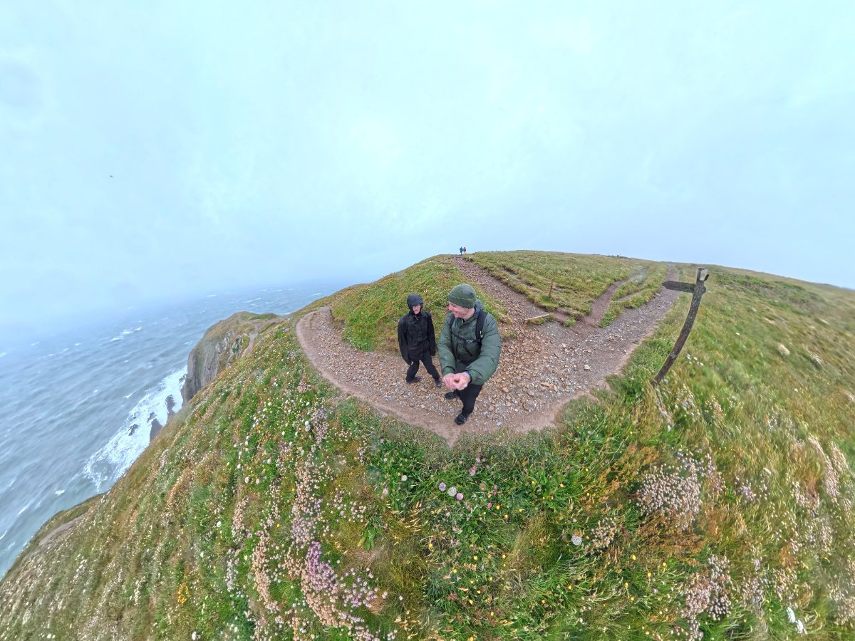
Now you're on the final leg out towards Baggy Point, and the views will only continue to get better and better. Before you know it, the point will be jutting out in front of you, with great views of small coves down to your right - I genuinely wish I could have seen this in the sun, because it would have been spectacular! Although I am one who thinks there is a certain charm to a misty vista, so I still loved being here. We tried to head out right to the point, and actually got most of the way out there, but a yellow weather warning for wind is not a time for bravery, so we got as close as we could stomach, snapped some photos and headed back to the safety of the wider pathways...
Now we were heading East, away from Baggy Point and towards Putsborough, and you already know what to expect: A mix of wide and narrow paths along the top of the cliffside, generally easy-going paths and nothing that should really pose too much of a challenge for most walkers. There are still new things to see, such as the Coastguard Pole. You of course get wonderful views all the way up, and as Woolacombe beach comes into view you have a choice to make. From here, you can continue north, enjoy the sands of Woolacombe beach or stay along Woolacombe Warren to extend the walk into Woolacombe town, or veer south to continue your Croyde loop. Today, soaked to the core and battered by winds, we naturally turned south, but if the weather is on your side, then extending your walk is certainly an option; as you can see above, this walk is about 7 miles, but if you decide to extend this walk including the Woolacombe loop, it will add on roughly 5 miles depending on the route selected.


As for our journey, we cut across the final field, somewhere near Christine's View Bench, to link back up with paved roads at Vention Lane, before snaking into the hamlet of Putsborough to check out the pond at the corner of Putsborough Road and Meadow Lane, where in warmer weather I am assured you can see terrapins bathing in the sunshine! A little way later, down the winding country lanes flanked by countryside and shaded by trees, we found ourselves back in Croyde, where even in the rain an ice cream from Croyde's Ice Cream Parlour went down a treat! Then we traced our route back down the road to return to the layby, ready to be free of the wet conditions and back in a warm, dry car.
This was certainly an interesting walk to summerise, without the assistance of a beautiful british summer's day, instead suffering through a typical British summers day, we had to endure a moderately torturous hike out to Baggy Point - but if anything, the challenging conditions only helped emphasise just how nice this walk is, a great view is a great view come rain or shine, and this walk is absolutely littered with those. I wholeheartedly hope you get better conditions on your visit, but if you find yourself fancying an adventure in any of the nearby beauty spots, then the Baggy Point walk should be high on your list; it is this perfect way to soak in views up and down this awe-inspiring stretch of coastline. Adding additional walks onto this is easy: as mentioned previously, the Woolacombe loop to the north is easy to link up with, as well as Saunton Sands to the south; the South West Coast Path links through here, so extending this walk all around Devon and beyond is possible, the only limit being your personal desire for adventure!
