
In the past I have spoken about so many fabulous adventures we have taken together, often compacting them into a short travel story but never really delving into the details. Today is one of those places, specifically the journey to Ynys Llanddwyn in Newborough Forest, this is a spectacular tidal island full of jagged cliffs and golden beaches combined with a wealth of history and picture-perfect viewpoints. I gave the overview of the journey in the lighthouse to lighthouse story but never really delved into what was on offer here. On the island are so many worthwhile sights including the well documented Goleudy Tŵr Mawr and the lesser well known Goleudy Tŵr Bach - two stunning lighthouses on either side of the rocky outcrops. Beyond this are a handful of other attractions including a number of crosses, the remnants of Eglwys Santes Dwynwen (a church that may date back to medieval times) and a set of charming cottages to explore around. There is a lot to take in and enjoy on this beauty spot, so let us map out an adventure to take you out onto this little rocky outcropping on Anglesey as soon as possible!
Reaching Newborough Forest is a simple drive down the Anglesey coast from the strait crossing to the corner of the island. Driving down the A4080 couldn't be easier, just follow the main road as it snakes around the little hamlets dotted around until you reach the town of Niwbwrch where you should begin to see brown signs for Ynys Llanddwyn Island and Llys Rhosyr - this will put you onto Church Street, a slightly more typical Welsh country lane but it is reasonably wide and has good sightlines for the most part. At the far end will be an island but with the only options being to pass through the gate into Newborough forest, or to return the way you came. Once you've paid the price of admission you can make your way on a short drive through the forest itself and down to the seafront - this is a road not quite wide enough for two cars but the large grass verges on both sides make it an easy place to pass. There are smaller car parks or laybys dotted around, but for the closest option just keep going until you reach the end and you will be in a spacious car park with toilets and easy access onto the beach. Those travelling via public transport may not necessarily be able to get close to the start of today's walk, but considering you'll be forced to walk through the enchanting forests that surround your destination it is hardly going to be a miserable journey. Busses from places such as Llangefni and Bangor will drop you to the nearby town of Niwbwrch, making getting here reasonably easy and connecting through from further afield easiest done via Bangor. All you will be left with is a roughly 2-mile walk through the trees.

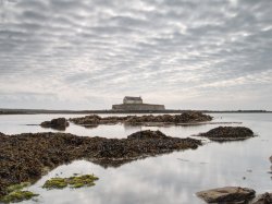
From the car park, you are now just a short trip down a boardwalk to start your trek down the beach - and what a beach it is! Beautiful golden sands, on our visit it may have been a little windswept, but it was still a nice enough day with some intermittent sun that we were able to kick off our boots and enjoy the sand between our toes. You can, of course, take detours via the forest - if this sounds preferable then there is the added bonus of a chance to spot red squirrels, but even if you aren't so lucky the trees here are alive with birdsong and the whole place is a great day out. We had a lovely walk up the beach, enjoying the calm waves lapping against the shore thanks to the protection offered by being sandwiched between Ynys Llanddwyn and the Welsh mainland. Plus, this beach seems to trap a good number of shells, so if you are a collector then there may be plenty on offer to sift through here.
Before long you will be staring down some rocky outcropping jutting up out of the sand, this marks the start of our walk today at Ynys Llanddwyn - hopefully, you have checked tide times and arrived with plenty of time to explore, ideally on a day where the high tide isn't particularly high and the tide has not long gone out. There is no issue with venturing on the island when the tide is on its way in of course, but you must be prepared to either remain on Ynys Llanddwyn for the duration of high tide or get your feet wet. The paths over the island are easy to follow and well maintained, in fact on our last visit they had been freshly relaid with seashells; using seashells in place of gravel or concrete is so much more aesthetically pleasing and when new gives a satisfying crunch underfoot, it is such a wonderful idea! Other sections, as seen above, were reinforced by a wooden pathway which made for a generally easygoing walk,
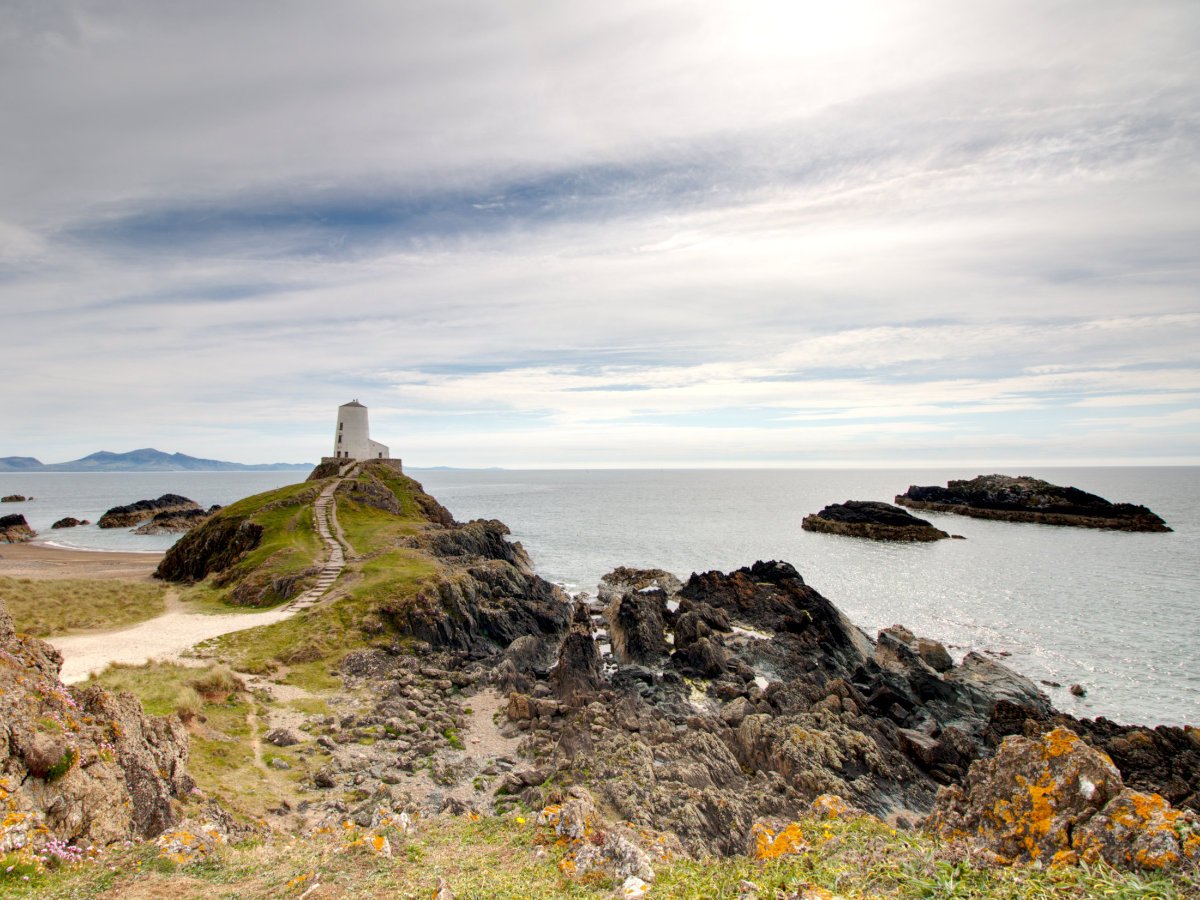
The best bet is to take a bit of a circular route around the island - we opted to scale the small hillside to our right as we arrived and follow the upper walk along the cliffs before returning via the central path. This upper walkway had some great views over the staggering cliffs down to the tucked-away beaches below and out to sea but was a bit more involved, for those looking for something a little more accessible you will want to follow the central path as it is wider and generally smoother. The island has a tonne of fantastic places to discover and certainly rewards exploration - while Tŵr Mawr may well be the main pull thanks to its Instagram fame there are plenty more picturesque spots to discover, often just a short walk away from the main central path.

If you look at the map above you can see roughly where all of the attractions are, the aforementioned Tŵr Mawr is at the furthest reaches of Ynys Llanddwyn and it will depend on which route you take as to what you will encounter first. There are plenty of great sights to see, starting with the ruins of Eglwys Santes Dwynwen, St. Dwynwen's Church, somewhere near the centre of the island. St. Dwynwen was the Welsh equivalent to St. Valentines, as she was the patron saint of lovers and the name Ynys Llanddwyn means island of the church of St Dwynwen. The church has likely stood as a parish church from some time in the 16th century but excavations in the area have revealed that former buildings on the site likely date back to the medieval era as a priory. Only a few walls remain of the church today but what a wonderful place this would have been to go to worship or even hold a wedding in such stunning surroundings. Two crosses stand on the island as well, both of these much more modern than the church itself but complement the landscape well and can be seen atop their respective hills from far around - one a traditional cross and the other one a Celtic cross, both make for great photos in their own regard.
Just before reaching the tip of the island, you will also pass by the Pilot Cottages, a charming run of small houses that also have a rich history. The Pilots had to help navigate ships into the Menai Strait, as well as operate a local lifeboat service - they would summon the lifeboat using the canon sat just outside the cottages. The cottages also operate as a small museum, giving a glimpse into the life of the pilots and what their homes used to look like. The old lifeboat station can be found next to Tŵr Bach on one of the furthest reaches of the island, this service was operated until 1903 by the pilots. It is quite incredible to imagine the workers living on this island, working hard to protect the commerce passing through the Menai Strait on such a spectacular piece of Welsh landscape - what an amazing place to live!

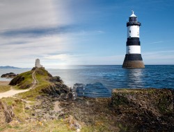
At the tip of the island are the two towers - Tŵr Bach, the small tower, and Tŵr Mawr, the tall tower, respectively. By most accounts Tŵr Bach was the original tower on the island, erected sometime in the early 1800s, it is situated on a little island of its own next to the lifeboat station which is linked via a stone causeway. The structure acted as an unlit lighthouse to be used as a marker for navigating ships into the Menai Strait. Tŵr Mawr would have followed in 1845 as a more typical lighthouse, although it is likely an unlit beacon similar to Tŵr Bach would have preceded it - the new lighthouse was better situated atop its rocky mound with a better view out to sea, meaning it could more easily aid ships to carefully navigate the mouth of the Menai Strait. The design of the building is reminiscent of a traditional windmill, and its beautiful whitewashed facade makes for an unquestionably awe-inspiring moment when you first catch glimpse of it; the bright white stone of Tŵr Mawr practically glows in the sun against the blues of sky and sea, but even on a less than perfect day this little building atop its hill is still picture-perfect.

Your return to the car park can see you either retracing your footsteps up the beach or plotting a new route back through the local woodlands. There is, of course, plenty of options for exploration beyond what you have already seen including a myriad of routes dotted through the trees and the rest of Traeth Llanddwyn (Llanddwyn beach) as it stretches out towards the mouth of the Afon Cefni. Anglesey has certainly become a bit of a love of ours, with many adventures mapped out around the island and so many memorable places, all within a reasonable distance drive - obviously we went from one side of the island to the other in a little road trip and there are beauty spots all around the coast including Beaumaris Castle also on the opposite side of the Menai Strait coast or perhaps you could pop to Plas Newydd about halfway across? If you fancy another good road trip then South Stack Lighthouse is right on the furthest reaches of Holy Island. But if you fancy something a little more local, just as breathtaking and also church themed then I wholeheartedly recommend popping along to the Church in the Sea just a short jaunt up the coast. Or just spend the day here! I certainly plan to, as my love for the beauty of Ynys Llanddwyn will keep me returning - well, that and my grim determination to finally see a red squirrel in the United Kingdom!