Exploring the Stiperstones

Post Banner
Help

At a glance

Key stats

Difficulty icon Difficulty: Intermediate
Distance icon Distance: 3.2 miles
Route icon Show Route

Brief Overview

Rough surface even on paths, stones harsh underfoot so strong boots recommended. Only one incline to get up then generally flat with a general ebb and flow.

Navigation

Navigate to: Stiperstones, Shrewsbury SY5 0NL
Latitude/Longitude: 52.573144, -2.932200
what3words: wage.unearthly.book

Help


Difficulty

Difficulty Icon

A rough estimate of difficulty, this does not factor in distance and is only based on the conditions of the route followed. A 20 mile walk on paved roads will be marked as beginner, whereas a 1 mile scramble up a mountain will be Advanced/Expert. Please consider both distance and difficulty when choosing a walk.

Beginner

Clearly marked routes that are easy going with smooth surfaces, little to no inclines or declines. Should be accessible to all.

Intermediate

May include some minor sections of uphill or downhill that could be a little challenging. Some surfaces may be loose or otherwise be difficult to pass. The vast majority of people should be able to tackle this walk, but good hiking shoes are absolutely recommended.

Advanced

Walks may be almost completely comprised of difficult terrain, be it up/downhill or difficult surfaces that are slippery or muddy. Some may struggle on this walk, hiking shoes and possibly hiking sticks are a must.

Expert

A very difficult walk, may require scrambling or climbing in parts. Appropriate preparation should be made before attempting these walks, as they may require additional equipment. These are very much for experienced walkers only and it may be worth having a guide who knows the area with you.


Length

Length Icon

A rounded estimation for the distance of the route shown, remember to factor in the return journey! Obviously, circular routes will end with you where you started, but any point-to-point walks have been doubled assuming you are going to retrace your footsteps. If the articles includes any suggestions for extra walks they will not be included in this value.


Route

Length Icon

The map displays a downloadable .GPX file that can be used in Satellite Navigation devices or apps. Walks shown will typically be the simplest route described in the article. Routes are for reference only, always remain on paths and be aware of your surroundings.


Navigation

We offer links to either copy or navigate to the destination, the navigate link should work on most modern platforms (If all else fails you can manually copy the text above the buttons!). It is recommended you use Latitude/Longitude rather than address whenever possible as it will be much more accurate and consistent across different navigation tools, but we understand that sometimes address is the only supported option so we include that too where applicable. Unfortunately, if your destination is in the middle of the countryside you may struggle to navigate by address.


Features

Parking available nearby Parking available nearby
Dogs welcome Dogs welcome
24-7 access 24-7 access

Local weather

High
Low
Wind Speed
Wind Speed
Sunrise/Sunset
Sunrise
Sunset
High
Low
Wind Speed
Wind Speed
Sunrise/Sunset
Sunrise
Sunset
High
Low
Wind Speed
Wind Speed
Sunrise/Sunset
Sunrise
Sunset
High
Low
Wind Speed
Wind Speed
Sunrise/Sunset
Sunrise
Sunset
High
Low
Wind Speed
Wind Speed
Sunrise/Sunset
Sunrise
Sunset

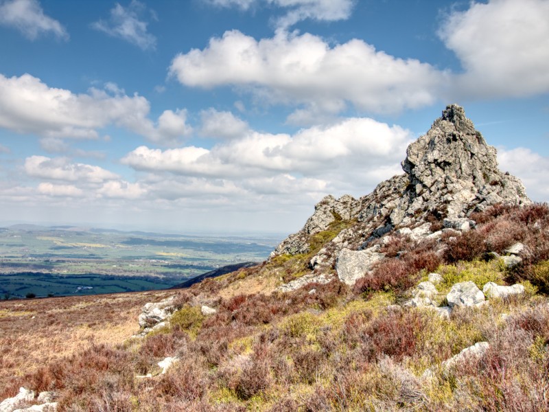
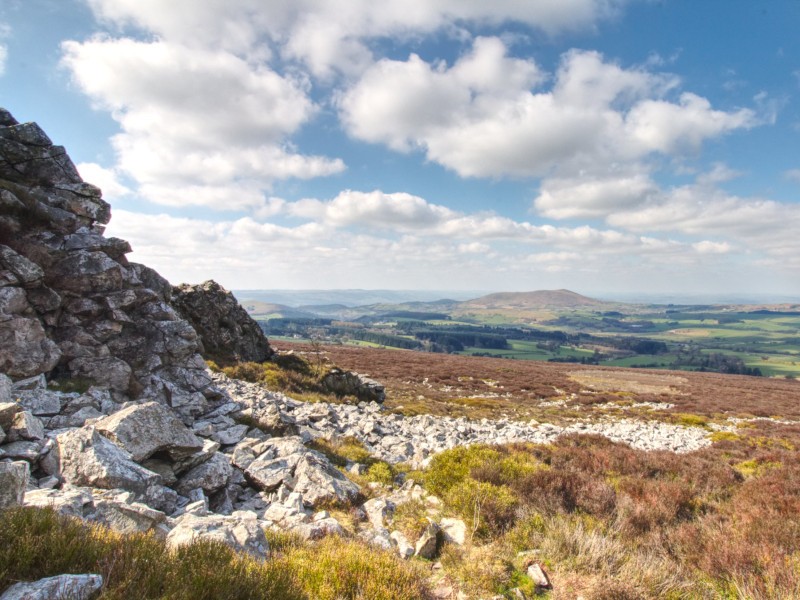
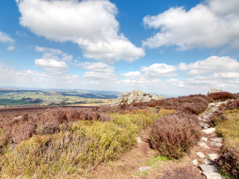
The Shropshire Hills have plenty of options for rambling adventures, but to me one of the most awe-inspiring and dramatic is the Stiperstones (52°34'24.8"N 2°55'54.8"W); comprised of a handful of tors (also known as a castle koppie or kopje - read more on Wikipedia), these incredibly unique peaks combined with a blanketing of heather give the area a really distinct look. I would recommend a visit in the Summer so you can see the heather in full bloom. Aside from the stones themselves, the area boasts amazing views and on a clear day you can see many of the other prominent peaks in the Shropshire Hills. When you arrive at the car-park there is a well marked circular walk along with information boards to learn more about the local flora and fauna - this is an area of Special Scientific Interest (SSSI), particularly for birds. Make sure you have a good zoom lens or a set of binoculars to get some bird spotting done, if you're lucky you might even spot a grouse or falcon.

Nearby and also worth a stop is "The Bog", which includes a visitors centre where you can grab some food and drink next to a former mining community. You can freely explore the site of the mining community and the entrance to the visitors centre features a lot of interesting information about the area.


If you follow the full walking route (Which will take you through all of the Stiperstones and The Bog) you are looking at a roughly 5 mile walk over some very rough terrain so, as I always recommend, you will want your best hiking boots and maybe some snacks so you can give yourself a break part-way - there is a definite risk of injury here as most of the paths extremely rocky, so do take care. However it is definitely worth the risk of a rolled ankle to get to the views that await you:

Manstone Rock

Cranberry Rock view south


Cranberry Rock view North

Another bonus to Stiperstones is they are well located in Shropshire to explore other nearby locations, such as one of our other favourite spots: Carding Mill Valley and the Long Mynd, and if you're looking to head further out you are right on the Welsh border - I recommend taking an hour-or-so drive to see Lake Vyrnwy and some of the stops around there (you can read a little about this in my road-tripping post where we pass through this area). If you're after a more built-up stop off then you're in luck, you are just south of the historic and beautiful Shrewsbury, on the way you could stop off at Attingham Park to see the house and their herd of deer.

Whatever your plans, if you find yourself in the Shropshire Hills i absolutely recommend a stop off to enjoy this unique spot, if for no other reason than to grab a few photos for your travelling scrapbook.


Related Content

Attingham Park - one spectacular building and some adorable residents Attingham Park - one spectacular building and some adorable residents

Always stay up to date

Never miss a post! Click the button to get notified on your device whenever new content goes live.

When you click the button your browser may display a prompt to display notifications, if this doesn't display you may have already disabled notifications.

We will never spam you, and only ever push notifications when we have something for you!

Turn on Notifications
Success
Something went wrong
Notifications enabled!
Something went wrong - your browser may be blocking notifications.