
Wales has a huge array of heavy industry in its history, vast scale enterprises that have left their marks in and around the gorgeous natural landscape. There is probably no more iconic export from the Welsh mountains than that of slate, the deep-greyish-blue stone can be seen lining the slopes of many a hillside and valley; often the rejected pieces, typically left behind due to their high iron content, are stacked so high they often form artificial hills all of their own. It may be tempting to write off an old slate quarry as a scar on the landscape, but in their own distinct ways, they create a unique vista that only grows more beautiful as nature slowly reclaims the area. Of all these kinds of beauty spots that hark back to Wales' industrial heritage, Cwmorthin must be amongst the most stunning.
Surrounded by still active quarries near the town of Blaenau Ffestiniog, Cwmorthin sits right in the heartlands of Snowdonia National Park. In fact, Snowdonia has a boundary that encircles the area, with this small hole in its centre to allow for the slate quarrying industry within to flourish. Cwmorthin itself was active as recently as 1997 but its history dates all the way back to 1810 when it was founded as an offshoot of the nearby Diphwys Casson quarry. Throughout its life, the quarry would see some success but difficulties that combined poor conditions for workers, difficulty expanding the underground chambers efficiently and fluctuations in ownership would eventually lead to its decline. You may note, I will use mine and quarry interchangeably to describe Cwmorthin, interestingly this was also a debate that the mine operators often had - trying to avoid certain rules and regulations by arguing they were, in fact, a quarry and not a mine.
To get to Cwmorthin, you will need to follow the A496 towards the smaller neighbour of Blaenau Ffestiniog, Tanygrisiau, and take the turning from the main road between the stone pillars, following the brown signs for Gorsaf Drydan Ffestiniog Power Station. When you first turn from the main road, Satellite Navigation may want to direct you straight and through Tanygrisiau's centre, but taking the turning mentioned previously that leads you past the reservoir is the easier route. Follow the road around past a cafe, over the train tracks and up the hillside - the road narrows as you progress but passing points are plentiful around here and visibility is great so no need to worry about the driving getting too difficult. Cross over a bridge and take a left once you arrive at some houses, the car park at Cwmorthin is at the end of this lane.

You only need to bail out your car and stroll up a short path before you arrive at the first attraction: Cwmorthin waterfall. Cwmorthin has a handful of waterfalls dotted around, and this first waterfall is a nice and sizeable cascade down a handful of rough edges that makes the perfect spot to psyche yourself up for the climb that awaits you - to the right of the waterfall is an ascent over the loose stone that will warm your calves up well, a relatively testing continuous gradient that just seems to stretch on-and-on. Once you have pushed your way to the top, the landscape will open up slightly and some of the first landmarks at Cwmorthin will pop into view. Be aware of the signs that warn of the dangers around here, the stacked loose stone does not make for a sturdy foundation so keep away from the edges and respect any barriers that there may be. As a general rule, just stick to anything that is clearly well-trodden and you should not have too much to worry about.
Your walk follows the same water that formed the first waterfall at Cwmorthin and once upon the first plateau there is a beautiful viewpoint well worth taking in - by turning right and travelling back on yourself a short jaunt you can see an awe-inspiring amount over Blaenau Ffestiniog and the surrounding valley. As you continue onwards, there are a whole host of routes that snake off just itching to be explored but, for now, stick to the main path as you ascend to the lake; if you fancy exploring further you can always break out a map but for now, we are going to keep this route simple and explore some of the main attractions of Cwmorthin. The map comes in handy because some routes lead to dead-ends whereas others will see you navigating up and over the mountains, so its best to know what lays ahead of you before you get yourself in a bit of a tizzy.

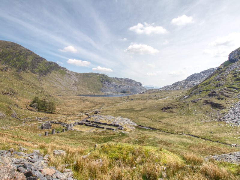
Once you scale the final small hill you will get your first glimpse of the lake, to your left are a handful of the old mining buildings that can be reached via a haphazard stone bridge (which you will need to cross anyway to continue the walk) and some more modern buildings to the right. The lake can be absolutely breathtaking in the right conditions, on our first visit the rain was bucketing it down and the clouds nearly touched the lake surface making the whole trip positively magical. On our second journey, the sun was shining and the weather could not have been more perfect - the sun glistened off of the surface while a chocolate lab merrily swam to shake the midday heat. The juxtaposition between the harsh slate edges and the smooth silky water with a sea of green as nature reclaims this area make every photo, from any angle, an absolute banger. As a walker, you will want to follow the path around the left edge of the lake but you may want to explore the right to see some of the old mine entrances - the cold air escaping the old mineshaft is absolutely chilling and something well worth experiencing. Potholers will find plenty to enjoy around Cwmorthin, and you will often see geared up explorers heading off for a day's spelunking - obviously this is something I only recommend trying with an experienced guide or at the very least equipped with the proper maps.

Following the path around the left side of the lake and you will gradually begin to drift away from the shoreline, and along the valley floor. Very quickly the piles of old rubble will disappear and the walk will take on a much more natural vibe; this section of the route has just a handful of building remains as you progress, but the most stunning by far is the old chapel. It sits alone roughly halfway between the edge of the lake and the upcoming ascent, against the backdrop of the sheer mountainsides and the few trees around it, the chapel becomes the kind of photo subject that is spectacular from every angle. Further on, at the base of the aforementioned ascent, is a collection of buildings remains, some of which has been converted into makeshift sheep housing for the local flock. There is a single waterfall here, a narrow stream of water bouncing all the way from the top of the mountainside - enjoy a moment's breather here, as the next climb may very well push your leg strength and, depending on your skill level, if you do not feel up to the challenge now is a good time to turn back.
If you decide to tackle the climb, be prepared for a fairly steep ascent that sweeps up and around the end of the valley; you should consider making your way partially up the path, just to get some of the amazing views back over Cwmorthin. The path itself is a real chore to navigate, made of loose stone that can be rough underfoot - you should take any necessary precautions to prevent against injury, as this path has a habit of moving from under you. Make sure you do take time as you climb to appreciate the views back over the valley, as the ruins slowly shrink away to little dots in the. Before long the path will briefly even out and you will be rewarded by another impressive little waterfall, and you now only have a small hill between you and the start of Cwmorthin's upper section. This is where Cwmorthin suddenly turns back into a proper quarry again, with remnants of old buildings barely still standing over the old slate piles with the adjacent rail lines slowly rusting away nearby; what was once a thriving little miner's work area now lies silent, but this gives us many options for exploration.

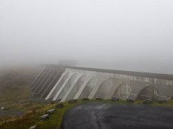
If you wish to continue there are many options from your current location, the most common option is to continue straight from where you came and ascend the mountain to the other parts of the mines, but there are so many options branching out from here you may need to take a map with you to fully appreciate the area. There are several attractions you may want to visit beyond here, including Stwlan Dam, Tanygrisiau Reservoir and walks that extend all around the mountain range. Cwmorthin is easily a full days adventure, especially if you are the planning to explore the underground sections too or heading out along the mountain ridge to see some of the gorgeous sights this part of Snowdonia has to offer, there is so much on display here both above and below! Even if you are after a shorter walk, there are plenty of points along the way that are worth the stop off even if only for an hour or two.
Hopefully, this will give you an idea of what Cwmorthin has to offer you as a walker and what could potentially grow into a full days adventure. This has really just scratched the surface of what you can hope to see, like with so many places around Snowdonia the possibilities for exploration are practically endless! Pack your best gear, obey the safety notices and enjoy a glorious romp around the perfect place to appreciate nature, history and industry in one convenient location. The mines may have been silent for years now, but they still have plenty to offer the dedicated explorers out there.