
If you have ever taken a road trip up the A470, perhaps up from Dolgellau on your way to Porthmadog or further north, then there is a very real chance you have noticed Llyn Trawsfynydd before - the sprawling blue waters sparkling in the sunshine over a rare section of flatland between the hills and mountains of Snowdonia. Even if you have never spotted the lake, or simply paid little notice to this reservoir, you might have caught a glimpse of that nuclear power plant looming over the tree line and wondered what the story is. Regardless, Lake Trawsfynydd is certainly more than a mile-marker along an A-road or a former cooling pond for the now decommissioned nuclear plant, it is well worth pulling into and spending some time adventuring around, so let us dive into what you can expect at Llyn Trawsfynydd...
As you may have already gathered, getting to Llyn Trawsfynydd by car couldn't be much easier, the lake's southern and northern points almost touch the A470 and there is ample parking at both ends. At the south, you'll want to leave the A470 up a short lane to reach the Trawsfynydd Lake Car Park, this is a single track road but its perfectly straight, very short and has enough passing points that you won't encounter any issues - just enter the car park cautiously as it can be fairly blind with the trees obscuring the view. Likewise, at the north end just turn into the Canolfan Prysor Centre area, signposted for the power station and café, and find somewhere to park, couldn't be simpler! Both car parks practically dump you out on the shoreline, so if you are looking for a quiet place to take a breather or a quick pit stop, you would struggle to find better surroundings in which to do so. Public transport, as with many areas around North Wales, is a little trickier but not impossible: buses run through the town of Trawsfynydd which sits on the land near the southern tip of the lake and, at the time of writing, there are a handful of semi-regular bus services that should make it possible to visit easily. In the grand scheme of things, thanks to the major A-road and the town of Trawsfynydd this is one of the easier places to reach.


Where you should be heading to is entirely up to you, but my recommendation is to park at the south end of the lake and walk along the east coast of the lake, cross the bridge to cut through the town of Trawsfynydd and follow the road until you can cut away to explore the fields and small woodland up to the Canolfan Prysor Centre. The footbridge that spans the southern section of Llyn Trawsfynydd is one of my favourite things to visit in the area, a glorious and memorable short stroll out into the open air above the lake that is worth a quick stop just to do that, but if you continue onwards then you are likely to see plenty of other spectacular views and some natural beauty in full bloom. For those a little unsure about the footbridge, the railings are around hip height and you can see through the slats to the water below but if you just focus on the horizon I am sure you will make it. It is a great spot to adventure around, or you can stay by the car park along the lake wall and enjoy a picnic or a spot of fishing, whatever floats your boat! If you wish to see the dam on the north-western corner of the lake then you could make one long walk of it by continuing through the little woodland and out to the Canolfan Prysor Centre, you can, of course, drive here if you didn't want to be walking too far but it should be worth considering that the walk to the dam is still a bit of a walk away and you cannot drive much closer due to the power station preventing access. The walk from the south car park to the Canolfan Prysor Centre car park is approximately 3 miles one-way, then the walk from the Canolfan Prysor Centre car park to the dam is around 1.7 miles, again one-way.
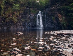
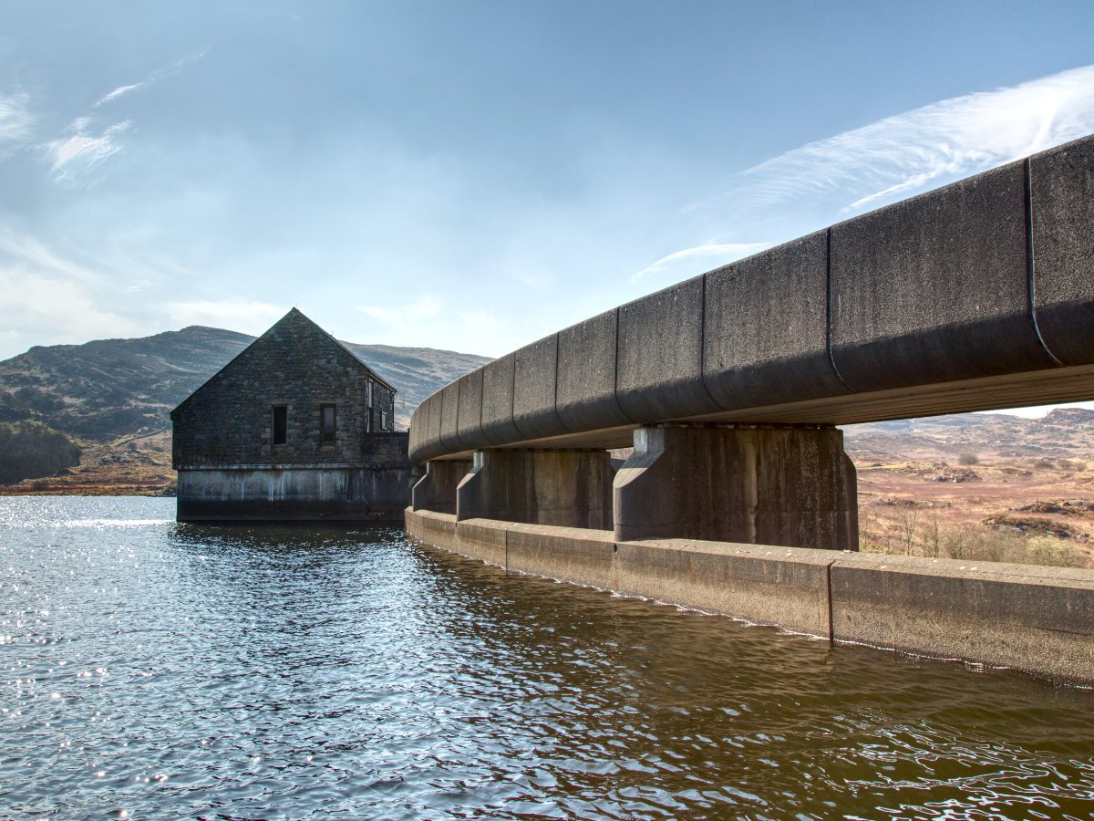
The walk from the Canolfan Prysor Centre to the dam at Llyn Trawsfynydd is an interesting one, it is almost exclusively on paved roads and pathways as you snake between the car park and power station and out onto the service roads. You should encounter little to no traffic on this road, but still, be aware that maintenance vehicles will occasionally appear. You will mostly be cutting through open areas, or bordered by woodlands but exposed so prepare appropriately for sunny days as you will have a brief respite from the sun. Be sure to enjoy the odd viewpoints you come across as you wander onwards, the lake is unquestionably stunning from most angles but here in particular with partially flooded islands and an odd sort of bar of earth running through it. It is difficult to envision the valleys underwater that formerly would have been sprawling farmland used to look like, but it certainly makes for a striking view. The dam will pop into view before you know it and there are ample viewpoints dotted around it, you can access lower areas at most corners of the dam as well as a great rocky outcrop to check out both the dam and the lake from over a stile tucked up the corner. Furthermore, take the path down from the opposite side and take a trip to get some great views of the dam itself from the bottom - if you were to continue following this path you would end up in Ceunant Llennyrch where this stunning waterfall can be found (Although we visited in two separate trips, so I cannot confirm that you can link these two walks into one).


There is an option for fully circular walks around the lake, should you fancy it, but because of the nature of the local landscape and buildings, you spend a lot of the walk away from the edge of the lake. This is a little unfortunate as we would all love to spend a day on the lake's shoreline, but a few stretches of the walk head up into the hills so you still get rewarded with some wonderful views out over the lake and beyond. The circular is one to consider if you want to make a full day of the Llyn Trawsfynydd and love to do a bit of walking, but if you are strapped for time, or just want to see the highlights, then stopping off at the dam and the footbridge will certainly see you satiated. The circular walk has great potential for cyclists, with multiple route options and large sections of paved road mixed terrain perfect for a cross-country or mountain biker to have a nice adventure around.
The history of the manmade reservoir is a little uneventful by Welsh reservoir standards, unlike some of its compatriots this lake was created without much opposition and with minimal displacement of locals - a few farms and historical buildings may have been lost but there were few protests. The dam itself was established in the late 1920s, and generally, locals were happy for the powerplant at Maentwrog as it would be able to meet the demands of the local populous as well as provide work. The major complaint from locals was the loss of the right of way around the area, to compensate for this the footbridge was constructed as well as a road on the western shore - helping to keep the areas now divided by a sprawling lake connected. Altogether there are four dams at Llyn Trawsfynydd, with the main one being Britain's first large arch dam and the others acting as cut-offs to prevent the extent of the lake from growing too large. With the opening of the Trawsfynydd power station in 1965, the lake would no longer primarily serve Maentwrog with water and would instead act as a cooling supply for Trawsfynydd's nuclear reactors. This, unfortunately, had an adverse impact on the local wildlife, as the cooling process increased the temperature of the lake killing off a lot of its natural residents. Since the start of the decommissioning process in 1991, the temperature of the lake has returned to natural levels and flora and fauna alike have both begun to regenerate - the waters here continue to serve the national grid as they are used for hydroelectricity. Interestingly, the nuclear power plant has been in a state of decommissioning for longer than it was operational, and while a bit of an eyesore against the mountainous backdrop it seems likely the plant won't be going anywhere anytime soon.


Llyn Trawsfynydd is a little bit unique on so many levels, between its history and function within the power sector combined with its beauty spots and great walks I think there is a great day out for most people here. Regardless of whether you simply want a peaceful spot to unwind for a moment or if you are looking for a grander walk (or ride) in some awe-inspiring surroundings, the lake has you covered. Plus, it is situated in a great location, sandwiched between the beautiful woodlands of Coed y Brenin and Ty'n y Groes in the south and the glorious Snowdonia mountains in the north; there are countless walks nearby, including some of our favourites including the Glasdir Copper Trail, Stwlan Dam and Cwmorthin and Rhaeadr Ddu. Those looking to drop in briefly on a longer adventure are in luck, thanks to the smooth A470 you can easily drop in on your way north or south, either from the wonders of northern Snowdonia or up from central Wales there is no excuse not to drop in, even if only for a quick stop - if I had to pick then I would absolutely recommend a quick stop at the bridge, there are some spectacular views over the lake here and we love returning to the bridge again and again purely for its uniqueness. A truly memorable place to adventure.
UPDATE September 2024: Sadly, the footbridge across the southern section of the lake has been closed - apparently due to structural issues. This, unfortunately, means you now must continue on past the end of the lake and follow the A470 to bypass the closure, bad news for walkers and anglers and frankly unacceptable for the children trying to get to Ysgol Bro Hedd Wyn, the local primary school. As far as I could find there are no plans to repair the bridge at this time. Please take the time to sign the change.org petition, and thanks to Tony Rudd for bringing this to our attention in the comments