Llyn Bodlyn reservoir

Post Banner
Help

At a glance

Key stats

Difficulty icon Difficulty: Beginner
Distance icon Distance: 6.8 miles
Route icon Show Route

This is a point-to-point route, so the distance assumes you will retrace your footsteps

Brief Overview

Generally smooth stone paths with gradual inclines/declines. Alternative routes may be muddy but primary route should be fine at any time of year. The area around the lake may be muddy and slippery in parts. The route distance includes return trip.

Navigation

Navigate to: Ffordd Gors, Dyffryn Ardudwy, LL44 2RJ
Latitude/Longitude: 52.787174, -4.074123

Help


Difficulty

Difficulty Icon

A rough estimate of difficulty, this does not factor in distance and is only based on the conditions of the route followed. A 20 mile walk on paved roads will be marked as beginner, whereas a 1 mile scramble up a mountain will be Advanced/Expert. Please consider both distance and difficulty when choosing a walk.

Beginner

Clearly marked routes that are easy going with smooth surfaces, little to no inclines or declines. Should be accessible to all.

Intermediate

May include some minor sections of uphill or downhill that could be a little challenging. Some surfaces may be loose or otherwise be difficult to pass. The vast majority of people should be able to tackle this walk, but good hiking shoes are absolutely recommended.

Advanced

Walks may be almost completely comprised of difficult terrain, be it up/downhill or difficult surfaces that are slippery or muddy. Some may struggle on this walk, hiking shoes and possibly hiking sticks are a must.

Expert

A very difficult walk, may require scrambling or climbing in parts. Appropriate preparation should be made before attempting these walks, as they may require additional equipment. These are very much for experienced walkers only and it may be worth having a guide who knows the area with you.


Length

Length Icon

A rounded estimation for the distance of the route shown, remember to factor in the return journey! Obviously, circular routes will end with you where you started, but any point-to-point walks have been doubled assuming you are going to retrace your footsteps. If the articles includes any suggestions for extra walks they will not be included in this value.


Route

Length Icon

The map displays a downloadable .GPX file that can be used in Satellite Navigation devices or apps. Walks shown will typically be the simplest route described in the article. Routes are for reference only, always remain on paths and be aware of your surroundings.


Navigation

We offer links to either copy or navigate to the destination, the navigate link should work on most modern platforms (If all else fails you can manually copy the text above the buttons!). It is recommended you use Latitude/Longitude rather than address whenever possible as it will be much more accurate and consistent across different navigation tools, but we understand that sometimes address is the only supported option so we include that too where applicable. Unfortunately, if your destination is in the middle of the countryside you may struggle to navigate by address.


Features

Dogs welcome Dogs welcome
24-7 access 24-7 access

Local weather

High
Low
Wind Speed
Wind Speed
Sunrise/Sunset
Sunrise
Sunset
High
Low
Wind Speed
Wind Speed
Sunrise/Sunset
Sunrise
Sunset
High
Low
Wind Speed
Wind Speed
Sunrise/Sunset
Sunrise
Sunset
High
Low
Wind Speed
Wind Speed
Sunrise/Sunset
Sunrise
Sunset
High
Low
Wind Speed
Wind Speed
Sunrise/Sunset
Sunrise
Sunset

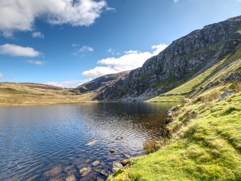
The landscape of North Wales is littered with small lakes and reservoirs often nestled in the shadows of towering mountains (or sometimes on top of) which make for beautiful views and spectacular walks. Llyn Bodlyn is a man-made reservoir, flanked on three sides by steep hills and rugged cliff faces and approached by farmland with some absolutely breathtaking views out over Cardigan bay. It has a modest dam, quite tiny compared to some others in Wales such as Vyrnwy or Trawsfynydd, but the spillways feed a constant flow of white water down to the ocean beyond in the form of the Afon Ysgethin - giving the landscape a very dramatic feel. This area may not have the biggest, tallest, most awe-inspiring or most beautiful of anything, but it is the perfect balance of everything Wales has to offer and because it is not so well known you will often get the place all to yourself.

Heading North out of Barmouth you will need to tackle a short country lane to our stop - considering how difficult some roads in Wales can be this is a fairly wide track with a generous amount of passing points so you can trundle up safely. As with many of these nestled away spots there is nothing really to sign-post it, you will need to follow a Sat-Nav to make sure you find the correct turning in the small town of LLanddwywe, just on from Tal-y-Bont. While the sat-nav may try to take you all the way to the lakeside, our actual destination is a small car-park with an honesty box. If you happen to have arrived here on horseback then feel free to follow the bridleway, otherwise park up and continue onwards on-foot closing any gates you pass and giving way to any vehicles you encounter.

View from Llyn Bodlyn approach


The remaining trek, if you follow the lanes rather than deviating, is roughly 3 and a half miles of loose gravel roads that are easy enough to follow and the gradient is nice and steady. The main road can easily be completed in comfy shoes or trainers, although further exploration will require something sturdier. You will wander through farmers lands, where we were greeted by one particularly vocal cow, and eventually out onto more open landscape with some opportunities to explore other paths. Even in September some of these paths were heavily flooded and very muddy, so plan for the worst or stick to the main roads - but if you are feeling more adventurous you can get views from above by following the marked trails, the turning to head up the mountainside can be seen here.

If you stick to the roads you will arrive at the lake in no-time. You can make your way down to the lakeside at any of the banks, but if you follow the road all the way to the end you will come to the dam itself. There is a small bridge to cross the spillway and you can explore the foot of the dam or make your way further around the lake. It is such a quiet spot, perfect for a picnic and to soak in the beautiful Wales countryside.

Enjoying the view


As ever in Wales the walks can go on as far as you want them to, you may have even noticed Llyn Lrddyn as you approached but there is also the smaller LIyn Dulyn nestled in the mountainside, feeding into Llyn Bodlyn. A quick look on Google Maps shows all the little lakes littered nearby - so you really are spoiled for choice if you want to go lake-hopping! Just another wonderful spot that Snowdonia has to offer, well worth a stop off on a sunny day for a quick afternoons hike.


Always stay up to date

Never miss a post! Click the button to get notified on your device whenever new content goes live.

When you click the button your browser may display a prompt to display notifications, if this doesn't display you may have already disabled notifications.

We will never spam you, and only ever push notifications when we have something for you!

Turn on Notifications
Success
Something went wrong
Notifications enabled!
Something went wrong - your browser may be blocking notifications.