
Welcome to travel diaries, where I tell the story of a recent trip and all of its trials and tribulations. Even with the best intentions, not all trips go according to plan, but we always try to make the most of them. This story is one from the archives, a mostly disastrous attempt at a day out from back in 2015, as such, most of the old photos are gone but considering our excursions are almost always successful, this one ended up being pretty damn memorable...
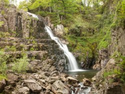
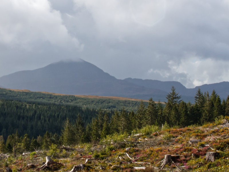
Coed-Y-Brenin is a wooded area just a short ride north of Ganllwyd in North Wales, it features a vast selection of different terrains with everything from easy grades along smooth gravel paths to steep and rough trails designed more for mountain bikes than ramblers. Snaking through the middle is the Afon Mawddach and its tributary the Afon Gain, which both have a number of tumbles and falls with the highlight of these being Pistyll Cain Waterfall. This sounded like a perfect adventure to us, as pitched by my parents who were avid fans of Coed-y-Brenin and neighbouring forests; woodlands, hiking, rivers and waterfalls are all high on our list of things to explore so we pencilled this walk into that week's itinerary and got on with enjoying that week in Wales.
When the day came we arrived at a moderately busy car park, but we knew these are expansive woodlands with multiple routes so we expected a peaceful roam around that would entail few encounters with other walkers. We paid up for our parking, made our way down to the boards to map out the route we were to follow; we opted for the red route as it guaranteed we would end up near the rivers to see the falls. The walk we selected was one of the longest, more scenic routes but we had plenty of time to explore as this was our last stop-off of the day.
Our journey started off great, the paths were smooth and wide and we didn't encounter a soul. The trees cast short shadows as the peak sun bore down, with the tallest of trees giving just enough shade to break from the baking sun overhead. The birds sang out merrily as we progressed onwards, this week had been a mixed bag in terms of weather so we were glad to finally have a bit of summer sunshine. We started out on shared paths, with different coloured signs indicating all the varied routes at Coed-y-Brenin, within a short time they each splintered off until we were out into the deeper woods exclusively following our red boot signs. It wouldn't be long before the structure of the paths changed a little, and after passing a few crossroads I started to get the feeling we had gotten a little turned around. Once we were truly into the depths of the woods, the route markers started to become less frequent, and while I think we did manage to stay vaguely on track I wouldn't be surprised if we took a few "shortcuts" here and there... Regardless, every time I started to question myself another little red waymarker would pop into view so I couldn't be doing too badly.
The paths went from interwoven and confusing to more gruelling, nothing we couldn't handle, but something that certainly tests your surefootedness and calf-strength. Sometimes we would be roaming through the dense forestry, transitioning into actual tracks used by vehicles before passing to narrow walking trails barely wide enough for single-file. The weather had a similar varying nature, switching from a cooking summers day, to drab overcast shadows that transition into brief refreshing showers, the kind that barely leaves a few droplets before the sunshine would return to dry us off. Eventually, the easy-going routes we had been enjoying gave way to something considerably steeper and made of very rough and sharp loose stones. Truth be told I was fairly certain we had stumbled onto a mountain-bike section, but as we carefully inched downhill we made friends with a lovely chocolate Labrador (and by extension, its owners), so we could only assume this was the correct path. We shared a laugh together about the surprising difficulty spikes and the bipolar weather on this walk and kept each other in good spirits, with the dog excitedly leading the charge with a little more haste than the humans could manage. By around the halfway mark, the roar of the river was within earshot and we finally had confirmation we were travelling in the correct direction.

Our final descent would almost immediately bring us to our goal, the bridge over the Afon Mawddach popped into view and below it a beautiful collection of construction machinery and barriers... It turns out, some form of construction work was in progress all along the river's edge which generally occluded the best views. We were certainly disappointed and started to weigh up exploring along the rivers and their various forks, but the works went on as far as the eye could see. While that may have been a lost cause we encountered a more pressing issue - the time; the unexpected shift in the conditions, the confusion at some of the crossroads and perhaps a too leisurely pace at the beginning means we were running out of parking time - we were at the point where if we dilly-dallied too much we would certainly meet our fate at the hands of a disgruntled traffic warden. The biggest decision was how we would get back, considering two factors:
- Based on the information board, we were less than halfway through the route
- The difficult routes we had already walked, that I had (at the time) felt we had gotten lost on a few times, would be difficult to follow in reverse
Rather than risk doubling back, getting turned around and being forced to continue on anyway or worse, get lost, we opted to double-time it back to the car. Continuing onwards with the walking route would have been just as risky and taken far too long, but instead of following the marked walk we opted to follow the 'escape route' - it looked to be a simple loop that swung around and back to the visitor centre, on wide-open smooth paths. We bid a quick farewell to our walking buddies, who had also decided to take the escape route but were not quite as strapped for time, and set off at a power-walking pace back to the car park.
At this point, we while we had enjoyed a lovely walk in nature, we failed to see the waterfalls we set out for and now we had to cut our journey short due to risking a parking ticket. The superstitious amongst you may believe bad luck comes in threes, so it will be no surprise that as soon as we started our marathon walk back the heavens opened; I'm not talking about a bit of a downpour, it was the kind of rain that forced us to stop to put on over-coats, over-trousers and wrap up our bags with waterproof covers to protect the contents from a drenching. Even with all of that, the rain was rolling off of us soaking us to our very cores, at points the rain was so aggressive it became difficult to see through the beads of rain running down our faces. If there was ever a silver lining to our situation, it was that the rain made for some good motivation to keep up our quickened pace, and we were certainly no longer feeling warm.

Completely wrapped in waterproofing and now charging along at full velocity, by going onwards rather than turning around I had a much better idea of where we were going; as far as I could see we were on something closer to a road than a path, all we would have to do is follow it and keep up the pace. The first concern was we were, of course, on the wrong side of the river at this point. Paranoia would begin to set in, as we saw another couple equally fleeing the downpour from across the river - had we made a mistake in crossing over? The sign we had encountered after crossing the river had suggested we should cross over, but we couldn't help but doubt our choice. All we knew was there had to be a crossing somewhere! Our frantic pace crossed with the horrendous weather meant I was having a tough time judging how far we had gone, I had begun to expect every corner to reveal the crossing only to be disappointed when all that popped into view was another turn in the river to power through. This would happen several times until, at long last, a footbridge appeared at the end of a gentle slope - a mildly arched metal framed and wooden slatted bridge, it was a glorious sight to our dampened souls. Of course, this bridge would mark the rough halfway point on our escape route, but you have to take any victories you can get!
Any fears of heights or waters were easily ignored, between the looming threat of a rapidly expiring parking ticket and the atrocious weather we scurried across, over the small car park and onto the paved road. Almost as a reward for our perseverance, shortly after stepping onto that paved road, the torrential downpour turned more into a summer shower and by the time we rounded the bottom corner and finally begun heading back in the right direction the sun had finally returned and worked quickly to dry us off. Aside from dodging a handful of cyclists and keeping up the pace to beat the clock, the final route was trouble free with markers for some of the easier and shorter routes we had seen on the information boards heralding our return to the visitors centre. Our day had gone from a glorious walk in nature to a disappointing adventure where we didn't manage to see what we came for and then to a disaster walk in miserable weather and finally back to a fun day out that we would laugh about in the future; this was rounded out perfectly by the parking ticket, that had just a minute left on it by the time I reached the car.

So what can we learn from this little misadventure? Well, this was the perfect combination of things both in and out of our control combining together to make the worst possible situation. I'm sure any adventurer reading this out there is more than familiar with the sheer panic from misjudging how much parking you need for a day out, it is a mistake we all make from time to time but it doesn't make it any less frantic when you're in the moment. Whether we misjudged the time needed or the difficulty of the walk based on the boards is irrelevant, this is one of those trips that really drove home for me the idea of over-estimating the time needed on any walk just to be safe - no one wants to overpay for parking, but a parking ticket issued by a traffic warden carries a steep fine so it is better to lose a few quid here and there. The weather is a fickle beast, one that is hard to predict and foolish to trust, so there is little point worrying about this and all you can do is pack the appropriate gear; in our case, the waterproof outer layers kept us from ending up bedraggled and miserable. Finally, what about the construction that had obstructed our views? Well, that one is certainly on us, however, that just gives us more of a reason to return at a later date and explore the woodlands in all of their glory!
Trips like these happen from time to time, they are enjoyable in their own right even if we don't fully appreciate them at the time - all you can do is keep your cool and know all will be well in the end. You end up chalking it up as an experience you will never forget, and hopefully learn a lesson or two from. If I had to give one piece of advice to anyone planning a trip: go for the red route if you can muster the strength! You will see most of what Coed-y-Brenin has to offer, although I hope for your sake the weather holds up (I'm sure the construction is long since finished). Hopefully, one day soon we will return to Coed-y-Brenin and give the walk a proper attempt in more favourable weather.