
Mountains to the north, ocean to the west, fields and forests as far as the eye can see - sound appealing? Cadair Idris is one of the more southernly Snowdonian mountains and it makes for one of the best walks in the area thanks to its spectacular views, where other mountains may be blocked in by their neighbouring peaks this one has some great sightlines well worth taking on the walk. The Pony Path will see you taking a slightly longer route than some of the alternatives but it is the best option for the newbie walker - a straightforward route with no major drops. While other routes may offer more sights and exciting routes, such as the stunning Llyn Cau on the Minffordd Path, if you have never taken on a mountain climb before and want to get a safe taster without ridgewalking or sheer drops this is a great starting point. Don't underestimate this walk, however, as you have a long uphill challenge awaiting you that will leave you with an enormous sense of pride when you reach the top - if you can rise to the occasion and reach the trig point then the more difficult paths are more than likely within your skill level too.
The car park is easy to reach, the roads are pretty nice for rural Wales so you won't have to deal with any farmers tracks or extremely narrow roads. The easiest approach is from the town of Dolgellau, taking a long uphill road out of the back of the town that narrows as you progress but it is still a fairly generous road by Wales' standards. There is not too much to report travelling this way, just keep following the road as it makes its way through the countryside - if you continued to follow this route you would eventually end up at Creggennan lakes (you, of course, have the option to come from that direction if you are coming from the coast near Fairbourne, be aware those roads are narrower and may require opening/closing gates as you progress), but keep an eye out for the parking signs just before a bridge on a bend. The main car park is fairly small but the overflow is plentiful and Cadair Idris is almost always a quieter option when compared to the more northern peaks. Parking is pay and display and you should really go for the all-day option, on my first visit to the Minffordd path, when I was a little green behind the ears and took that hike on a whim, I only purchased the 4-hour option - that was a mistake, it would take a fit hiker to get there and back in 4 hours (although certainly achievable and kudos to those of you that can) grab the full day of parking so you can forget about the clock and just enjoy your day.


To get started, head back to the car park entrance and turn right, following the signs for Cadair Idris. Enjoy this brief section of smooth asphalt, you will very quickly have to give it up for the rougher tracks via an unpaved road on your right; the first part of the walk will take you uphill gently, past a farm and through a beautiful bit of woodlands. This area is a lovely beginning, make your way through the kissing gates, over the streams and beneath a canopy of trees providing cover from any elements you may be facing. If you are hiking on a warm day or a rainy one enjoy the foliage while you can, before long you will pass the tree line and be exposed to the weather. As you progress the paths turn from small stones to large stones and eventually to stairs as the initial ascent begins proper. It has to be said that this initial part is probably one of the harder going parts; if you find yourself struggling a little try to push through and once the stairs give way to the flatter paths coming up you might catch a second wind. If you need a bit of motivation, you won't have to wait long before the views start, keep checking behind you as the lovely views over this little valley slowly reveal themselves - a small taste of whats to come.
The stairs give way to a mixture of different surfaces, one minute you will have large stones set into the grass, then smaller loose stones and sometimes muddier earth to navigate. This area will feel like a bit of break compared to the stairs, at some points you will be walking out in grassy fields which were much easier going for me and it is a nice area to recover before pushing on to the next big climb. There isn't too much to say here other than try not to let the looming mountain in-front of you put you off, it looks far worse than it is and before long you will be right up there! There is a handful of gates to pass through but the route is easy enough to follow, just keep going forwards. Some parts of this bit were a little flooded, especially one area directly after passing through a gate opened straight into a stream so just pick your footing carefully to avoid soggy socks. You will briefly follow a wall, after which the large stones set into the ground will start again - before long the stairs will start too but don't worry too much, these snake up the hillside and are, in my opinion, easier going than the first set of steps (or maybe by this point I was just well warmed up and ready for the challenge!). What you should be aware of is a short section of scrambling about halfway up, on one of the corners the path becomes a little ill-defined and requiring a hand plant to get up, so pick your route carefully and it should barely be an issue.


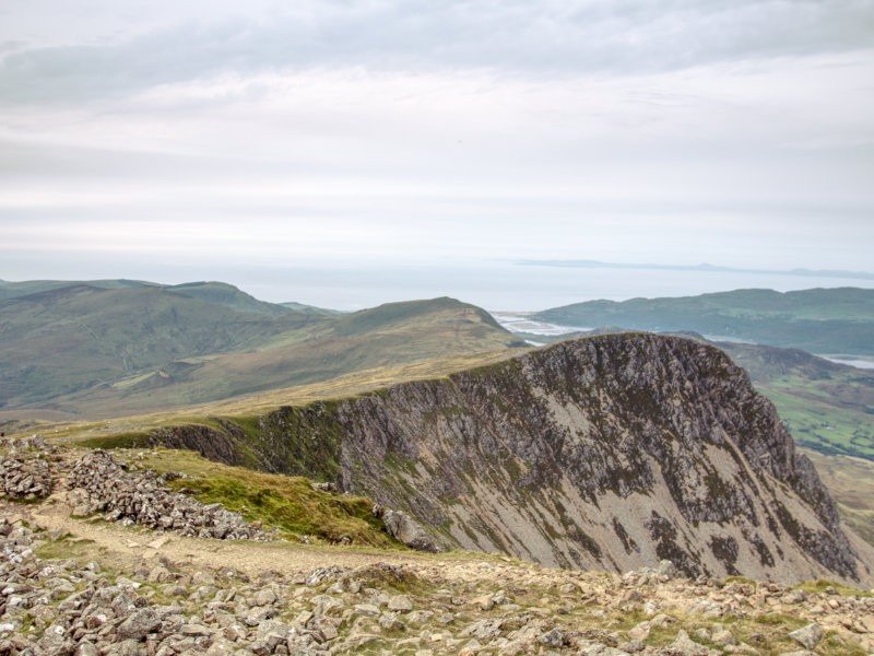
As you make your way up here keep your eye on the big boulder near the top (it is certainly hard to miss), consider this your goal as it marks the path beginning to ease. When the path returns to a loose stone that almost feels flat compared to what you have conquered so far, you have reached what can be considered the beginning of the top - still plenty to go but you can give yourself a pat on the back for what you have done so far. Nothing for a little while should surprise you, although you are about to head into my least favourite part of the walk: the big, loose stone paths. These chunky, sharp rocks are a great way to roll an ankle when combined with the fact you're already a bit knackered, so please walk carefully and choose boots with good support for the walk and consider breaking out the hiking sticks for extra purchase as you progress. On the plus side, while you previously only had views behind you there should now be the starts of a spectacular panorama forming in every direction - even though you may be tiring, the breaks you take in these surroundings are certain to fill you with energy. As you progress, the rocky route can get a bit difficult to follow in parts as you often find yourself in a large open patches of stones, you will probably be walking staring at your feet for this part so make sure you look up from time to time to avoid straying too far from the path. The last thing you want to do on a long walk is to spend time walking the wrong way, nothing is more killer to your motivation than having to backtrack. The walk doesn't change a lot from here on out, the surface may briefly change but, for the most part, those chunky rocks will be your nemesis for a while. Hopefully, the spectacular Snowdonia that is slowly seeping into view keeps your spirits high.


Nothing can explain the joy you feel when the trig point pops into view, you will feel the weight being lifted and suddenly feel recharged knowing the end is in sight. Not only that but as an added bonus you will get a great view over Llyn Y Gader here, obviously those who dislike heights may want to skip this part but if you have the stomach for the edge this is a great spot for a break. Keep on keeping on until you reach the final challenge, a fun scramble to top! There is a fairly clear path to follow up, and while it may split into parts there isn't a right and a wrong route here - just take your time and keep reminding yourself that you are so close to the finish line. If you are struggling to try to use the edges for support rather than scrambling up the middle, and if you find yourself unable to continue just double-back and pick a different option - no way are you quitting now! If you look at the picture above you can see two almost walls on either side, keep a hand planted on those for balance and use your other to hoist yourself to the top; stood at the bottom this looks like a colossal climb but please do not let that put you off as I promise you it will be over quicker than you think.
You can breathe a sigh of relief once the scramble ends, while you may not be quite to the trig point you are just a short uphill walk to the finish line. There is no real defined path to the trig point, just pick any path you like up the stones and plant your hand on the concrete to mark the end of your journey. The top has a lot going on, unlike Snowdon, there may not be a train station up here but there is a surprising amount of green space up here, usually with a handful of recovering walkers enjoying the views - and what views they are! Don't leave without checking out the amazing landscape from every possible angle and don't get put off if you have hiked on a day with poor visibility, try to appreciate sitting amongst the clouds as an awe-inspiring adventure. The other feature up here is the shelter not far from the trig point; I certainly hope you never have to use it, but this building is a godsend for those who get caught in inclement weather. Those are just the immediate features, of course, if the conditions allow for it the reason you have made it this far is to see those aforementioned magnificent views - Cadair Idris does not disappoint here! On one side are sharp drops leading all the way out to the Mawddach estuary where you can catch a glimpse of Barmouth and on clear days see clear to Bardsey Island, to the other side are rolling hills with so much potential for exploration. Shutterbugs will be merrily capturing every angle until their hiking companions are forced to drag them back down!


Once you have recharged and allowed your feet to cool down, it is time to get back to the car park. This particular walk is not a circular so you already know what to expect on the return journey, retrace your footsteps and before long you will have made it back - unsurprisingly, the return journey is much easier with the only challenge being slowing yourself down on the steeper downhill sections. That said, the rough loose stone paths mentioned previously can make following your actual path a little challenging as in sections there just isn't a well-defined route; as with the way up, its important here to pay attention where you are going and look for any familiar landmarks to help you navigate. If you have a GPS, or a navigation app on your phone, having the route mapped out can make it much easier to figure these parts out, but at least they are few and far between. There is certainly nothing to worry about on the return walk, just enjoy watching those gorgeous views slowly shrinking back into the ground as you make your way back and nothing will surpass the feeling of kicking off your hiking boots at the end of a good long walk.
So how long and how difficult is this walk? My timings are not the best to judge off of for reasons I will explain, but by breaking down my times and giving you some caveats you should have a good idea of how long it will take you. Firstly, remember we pack heavy, even ditching the 10lbs of camera gear could make a massive difference. On the way up I stop near-constantly to take photos on both my phone and camera, plus it was very hot so many water breaks were littered in too. Conversely, on the way down I don't think we stopped once and we managed to keep what I consider a really good pace (we were a little motivated by looming grey clouds). My GPS recorded the route and from the car park to trig point took 3 hours up and 1 hour 30 minutes down - I think a more focused walker, even a beginner, could shave a bit off of that uphill time. I know this makes it seem like someone could easily get up and down within that 4-hour parking window, but we also spent the best part of an hour at the top and we only left when we did due to the threat of rain - don't force yourself to cut your time at the top short just because parking is running out. As far as difficulty goes, our rating system, seen in the box at the top of the page, calls it advanced purely because of a few scrambles pushing the up the challenge but it is almost entirely an intermediate walk that I believe most folks could take on. While beginner walkers will certainly build up a good sweat on this route, I recommend this as a great walk for your first mountain ascension; it is a great taster of everything that makes mountain walks fun, without some of the hairier bits that may put beginners off.
The Pony Path is one of the best options to see a great range of unforgettable landscapes for many people of different skill levels and experience. If you have spent some time walking but haven't taken on a mountain yet then this is absolutely an excellent candidate for your first. Often in articles, I suggest some great things to do in the same area, but this will almost certainly be the only thing you do that day, especially if you are new to walking you should be careful not to overexert yourself. That said, if you have been there and back again and still want to ramble some more you still have great options nearby such as Cregennan Lakes, the Torrent Walk and Dolgoch Falls - all excellent options that do not take anywhere near the physical toll scaling Cadair Idris will have done. As far as your new-found career goes as a mountain climber, Wales has no end of options for you; you can either take on one of the many other paths up Cadair Idris, such as the beautiful Minffordd Path past Llyn Cau or you can look to the north where mountains are plentiful as you gravitate towards Wales tallest peak: Snowdon. But those are tales for another day, for now, bask in your success and tell everyone you know that you just climbed a mountain.
