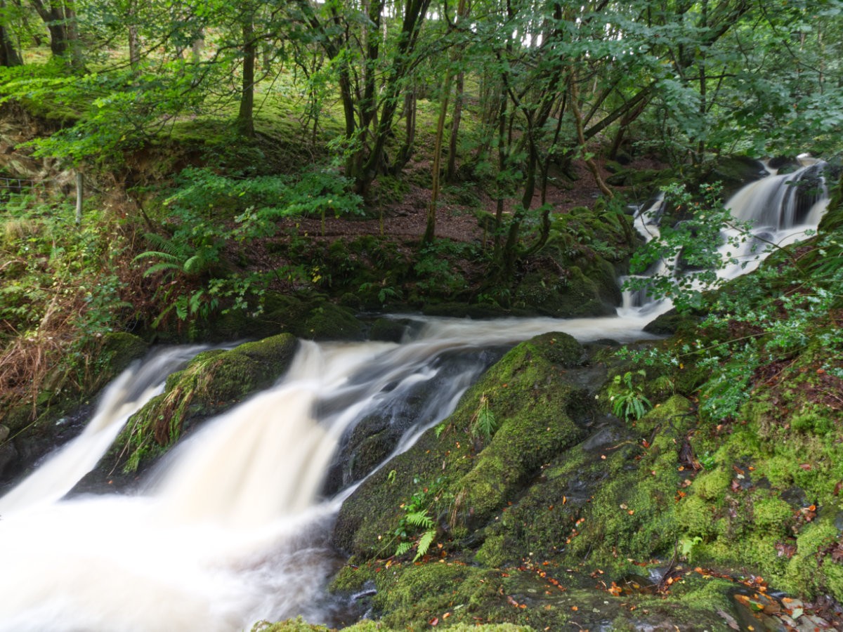

Driving through the town of Arthog, you would be forgiven for assuming there is nothing but a sleepy little village nestled at the base of the foothills of Cadair Idris. But hidden behind the dense canopy of leaves and behind the traditional Welsh stone walls is a group of cascades carving their way down the hillside that is well worth a stop-off, especially if you happen to find yourself already ambling down this side of the Mawddach Estuary. If you fancy a peaceful stroll in nature and want to spend some time listening to the roar of a beautiful set of falls then this is certainly the place for you - plus, like many of my favourite walks, this one can easily be tacked on to a much greater adventure with a little bit of planning.
Getting to Arthog Falls is simple, although parking may prove more of a challenge - if it wasn't for the parking situation, you could potentially consider Arthog Falls one of our quick stops. The town of Arthog is on the A493, between Fairbourne and Penmaenpool (the toll-bridge adjacent hamlet), it may feel like little more than a handful of terrace houses and a church but this is a lovely little village with a great connection to many sprawling walks. If you are navigating the old fashioned way and don't know which little blob of buildings is Arthog, keep an eye out for the road narrowing slightly as it turns over a bridge, this bridge is you crossing the Afon Arthog. There are no obvious markers for the falls, no dedicated car park and if you didn't know what to look for you wouldn't know where to go - but there are walks around here that can get you from quieter surroundings and back to where you need to be on the A493. There is a small car park near the Mawddach trail (a walking route that runs alongside, as you may be able to deduce, the Mawddach Estuary). The turning is near the church at Arthog, right around here; your route will pass through gates that you may need to shut behind you but keep heading down the lane until you arrive at a small space of parking on the left with a few picnic benches.

If I was to offer an alternative to driving, being so closely situated to the Mawddach Estuary and the aforementioned Mawddach Trail, Arthog Falls are a great candidate to combine with this walking route to create a full day's walk. For our last visit, we started out from Barmouth town, crossed the ever wonderful Barmouth Bridge on a still day with scorching sunshine and then enjoyed a shaded walk along the trail before turning off to arrive at the falls. Alternatively, you could start out from Dolgellau and walk in the opposite direction or, if you fancy a good descent down/climb back, you could start out from Cregennan Lakes and make your way down to the falls - a tough walk that will be a great strain on your ankles.
Assuming you are starting out from the previously mentioned car park on the Mawddach Trail (whether you parked there or walked the trail to this point), let's now map your walk to the falls. The simplest route is to head up the lane all the way up to where it joins with the A493, take a left and head towards Arthog along the road edge; there are no paths in this area and the roads narrow in parts so just take it steady and tuck in whenever the cars come past. Alternatively, you can cut the corner somewhat by following the footpath that diverges along a field beside the Afon Arthog - this is my preferred route as you spend less time on the road and more time walking alongside a peaceful babbling brook while the sheep look at you quizzically. From here, continue up the A493 towards Arthog (I prefer to stay on the left, on the same side as the church, as if the worst-case scenario happens and you encounter a couple of busses trying to pass in the narrow stretches, you can at least sit on the wall to get out of their way), and keep an eye out for an opening on the opposite side of the road - if you reach the driveway opening just before the bridge you have gone too far and if you cross the bridge you have definitely gone too far. In peak summer with the trees in full foliage, the opening can be tricky to spot, but the slabs leading up to the gate should be just about noticeable.

With that bother out of the way, you are now free to enjoy the falls - you can probably already hear them, but you need to make your way up the hillside before you can see anything substantial. The ascension is nothing too draining, slabbed stairs sticking out of the hillside have the potential to be a bit muddy and wet but nothing that should deter you from visiting. Follow the path straight up until it evens out slightly, ignore a narrower path off to the right instead trek onwards until you reach a bridge over the falls.
This spot to view the falls may be familiar to anyone who has visited Cregennan Lakes in the past, as just up the way you can join the main road up to the lake from this side. You can explore a little around this area but the lower stretches of the falls appear to be mostly blocked off - scrambling upwards may be a bit muddy and mucky but the falls have a different character from every angle, so it might just be worth wandering around. Still, even if you choose to just admire the falls from the bridge for a moment, this is a wonderfully tranquil spot well worth the exertion to scale the little hill.

Longer walks follow the Afon Arthog all the way up to Cregennan lakes, the aforementioned right path you avoided on the way up should let you explore the greater area and routes around here can take you all around the hillside, onto the lakes and beyond. One of the best things about Arthog Falls, in spite of its hidden away location that feels a little difficult to reach, is its great connectivity with other beauty spots and walkways in the area. This is a perfect fill-in spot to stop off at and as I often say, if you want to turn it into a days adventure you can just pick a path and wander onwards!
Hopefully, this taster of what you can expect from Arthog Falls has got you pencilling in a stop somewhere in your next adventure - it's such a great spot that you can often have all to yourself. This place is a walkers dream considering its isolated space, sure you can get here by the near(ish) car park, but donning your walking boots and sauntering your way down the Mawddach Trail as a nature-filled preamble to your waterfall adventure. Whatever your preferred route, if you do find yourself in the area Arthog Falls is well worth dropping by to grab a photo or two and to just enjoy the moment.